You are here: Home > Network List > TA - USArray Transportable Network (new EarthScope stations) Stations List
> Station L27A T5 Ranch, Ellsworth, NE, USA > Earthquake Result Viewer
L27A T5 Ranch, Ellsworth, NE, USA - Earthquake Result Viewer
| Earthquake location: |
East Of Kuril Islands |
| Earthquake latitude/longitude: |
46.9/155.2 |
| Earthquake time(UTC): |
2009/01/15 (015) 17:49:39 GMT |
| Earthquake Depth: |
36 km |
| Earthquake Magnitude: |
6.9 MB, 7.5 MS, 7.4 MW, 7.4 MW |
| Earthquake Catalog/Contributor: |
WHDF/NEIC |
|
| Network: |
TA USArray Transportable Network (new EarthScope stations) |
| Station: |
L27A T5 Ranch, Ellsworth, NE, USA |
| Lat/Lon: |
42.08 N/102.32 W |
| Elevation: |
1186 m |
|
| Distance: |
68.0 deg |
| Az: |
51.612 deg |
| Baz: |
313.73 deg |
| Ray Param: |
0.056541026 |
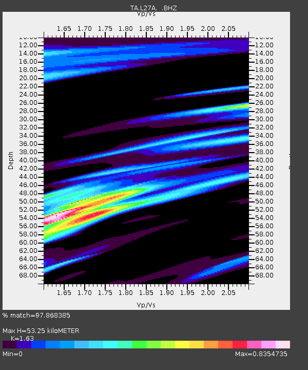
| Estimated Moho Depth: |
53.25 km |
| Estimated Crust Vp/Vs: |
1.63 |
| Assumed Crust Vp: |
6.483 km/s |
| Estimated Crust Vs: |
3.977 km/s |
| Estimated Crust Poisson's Ratio: |
0.20 |
|
| Radial Match: |
97.868385 % |
| Radial Bump: |
272 |
| Transverse Match: |
91.94333 % |
| Transverse Bump: |
400 |
| SOD ConfigId: |
2834 |
| Insert Time: |
2010-03-06 19:09:25.613 +0000 |
| GWidth: |
2.5 |
| Max Bumps: |
400 |
| Tol: |
0.001 |
|
Signal To Noise
| Channel | StoN | STA | LTA |
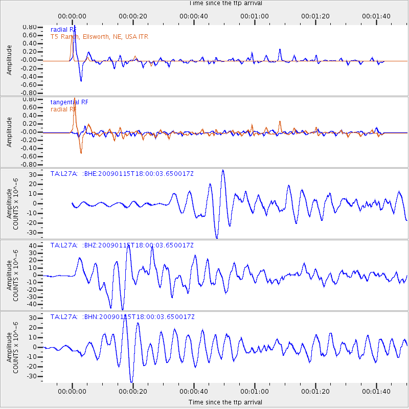
| TA:L27A: :BHZ:20090115T18:00:03.650017Z | 30.807177 | 1.2041052E-5 | 3.908522E-7 |
| TA:L27A: :BHN:20090115T18:00:03.650017Z | 2.2745867 | 4.282195E-6 | 1.8826255E-6 |
| TA:L27A: :BHE:20090115T18:00:03.650017Z | 3.2962475 | 5.8047613E-6 | 1.761021E-6 |
| Arrivals |
| Ps | 5.4 SECOND |
| PpPs | 21 SECOND |
| PsPs/PpSs | 26 SECOND |


