You are here: Home > Network List > TA - USArray Transportable Network (new EarthScope stations) Stations List
> Station L27A T5 Ranch, Ellsworth, NE, USA > Earthquake Result Viewer
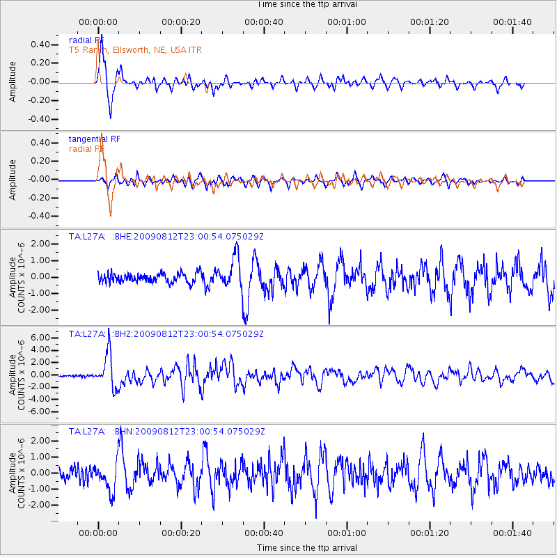
L27A T5 Ranch, Ellsworth, NE, USA - Earthquake Result Viewer
| Earthquake location: |
Southeast Of Honshu, Japan |
| Earthquake latitude/longitude: |
32.8/140.4 |
| Earthquake time(UTC): |
2009/08/12 (224) 22:48:51 GMT |
| Earthquake Depth: |
53 km |
| Earthquake Magnitude: |
6.2 MB, 6.6 MW, 6.6 MW |
| Earthquake Catalog/Contributor: |
WHDF/NEIC |
|
| Network: |
TA USArray Transportable Network (new EarthScope stations) |
| Station: |
L27A T5 Ranch, Ellsworth, NE, USA |
| Lat/Lon: |
42.08 N/102.32 W |
| Elevation: |
1186 m |
|
| Distance: |
85.8 deg |
| Az: |
41.553 deg |
| Baz: |
311.384 deg |
| Ray Param: |
0.04439709 |
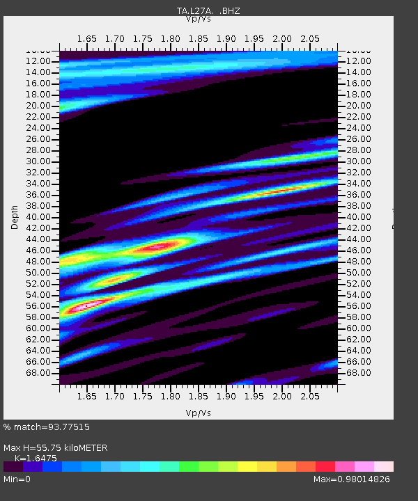
| Estimated Moho Depth: |
55.75 km |
| Estimated Crust Vp/Vs: |
1.65 |
| Assumed Crust Vp: |
6.483 km/s |
| Estimated Crust Vs: |
3.935 km/s |
| Estimated Crust Poisson's Ratio: |
0.21 |
|
| Radial Match: |
93.77515 % |
| Radial Bump: |
369 |
| Transverse Match: |
76.28714 % |
| Transverse Bump: |
400 |
| SOD ConfigId: |
2622 |
| Insert Time: |
2010-03-06 19:09:26.778 +0000 |
| GWidth: |
2.5 |
| Max Bumps: |
400 |
| Tol: |
0.001 |
|
Signal To Noise
| Channel | StoN | STA | LTA |
| TA:L27A: :BHZ:20090812T23:00:54.075029Z | 23.511131 | 2.888669E-6 | 1.228639E-7 |
| TA:L27A: :BHN:20090812T23:00:54.075029Z | 2.6709979 | 9.333669E-7 | 3.4944503E-7 |
| TA:L27A: :BHE:20090812T23:00:54.075029Z | 3.6071312 | 9.684821E-7 | 2.6849094E-7 |
| Arrivals |
| Ps | 5.7 SECOND |
| PpPs | 22 SECOND |
| PsPs/PpSs | 28 SECOND |


