You are here: Home > Network List > TA - USArray Transportable Network (new EarthScope stations) Stations List
> Station L27A T5 Ranch, Ellsworth, NE, USA > Earthquake Result Viewer
L27A T5 Ranch, Ellsworth, NE, USA - Earthquake Result Viewer
| Earthquake location: |
Near Coast Of Venezuela |
| Earthquake latitude/longitude: |
10.7/-67.9 |
| Earthquake time(UTC): |
2009/09/12 (255) 20:06:24 GMT |
| Earthquake Depth: |
10 km |
| Earthquake Magnitude: |
6.3 MB, 6.4 MS, 6.3 MW, 6.3 MW |
| Earthquake Catalog/Contributor: |
WHDF/NEIC |
|
| Network: |
TA USArray Transportable Network (new EarthScope stations) |
| Station: |
L27A T5 Ranch, Ellsworth, NE, USA |
| Lat/Lon: |
42.08 N/102.32 W |
| Elevation: |
1186 m |
|
| Distance: |
43.4 deg |
| Az: |
322.24 deg |
| Baz: |
126.052 deg |
| Ray Param: |
0.07259593 |
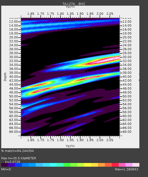
| Estimated Moho Depth: |
30.5 km |
| Estimated Crust Vp/Vs: |
2.07 |
| Assumed Crust Vp: |
6.483 km/s |
| Estimated Crust Vs: |
3.128 km/s |
| Estimated Crust Poisson's Ratio: |
0.35 |
|
| Radial Match: |
94.244354 % |
| Radial Bump: |
253 |
| Transverse Match: |
83.6356 % |
| Transverse Bump: |
400 |
| SOD ConfigId: |
2622 |
| Insert Time: |
2010-03-06 19:09:29.640 +0000 |
| GWidth: |
2.5 |
| Max Bumps: |
400 |
| Tol: |
0.001 |
|
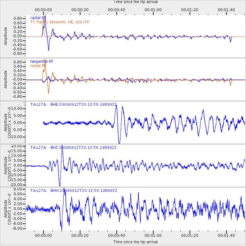
Signal To Noise
| Channel | StoN | STA | LTA |
| TA:L27A: :BHZ:20090912T20:13:56.198992Z | 9.460823 | 2.2225101E-6 | 2.3491721E-7 |
| TA:L27A: :BHN:20090912T20:13:56.198992Z | 1.0320706 | 5.692743E-7 | 5.515846E-7 |
| TA:L27A: :BHE:20090912T20:13:56.198992Z | 1.603436 | 8.3791787E-7 | 5.2257644E-7 |
| Arrivals |
| Ps | 5.3 SECOND |
| PpPs | 14 SECOND |
| PsPs/PpSs | 19 SECOND |


