You are here: Home > Network List > TA - USArray Transportable Network (new EarthScope stations) Stations List
> Station L27A T5 Ranch, Ellsworth, NE, USA > Earthquake Result Viewer
L27A T5 Ranch, Ellsworth, NE, USA - Earthquake Result Viewer
| Earthquake location: |
Hokkaido, Japan Region |
| Earthquake latitude/longitude: |
41.8/143.4 |
| Earthquake time(UTC): |
2009/06/05 (156) 03:30:33 GMT |
| Earthquake Depth: |
29 km |
| Earthquake Magnitude: |
6.0 MB, 6.3 MS, 6.4 MW, 6.4 MW |
| Earthquake Catalog/Contributor: |
WHDF/NEIC |
|
| Network: |
TA USArray Transportable Network (new EarthScope stations) |
| Station: |
L27A T5 Ranch, Ellsworth, NE, USA |
| Lat/Lon: |
42.08 N/102.32 W |
| Elevation: |
1186 m |
|
| Distance: |
77.6 deg |
| Az: |
44.032 deg |
| Baz: |
315.743 deg |
| Ray Param: |
0.05019252 |
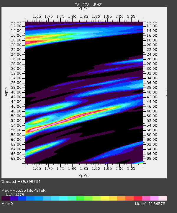
| Estimated Moho Depth: |
55.25 km |
| Estimated Crust Vp/Vs: |
1.65 |
| Assumed Crust Vp: |
6.483 km/s |
| Estimated Crust Vs: |
3.935 km/s |
| Estimated Crust Poisson's Ratio: |
0.21 |
|
| Radial Match: |
89.899734 % |
| Radial Bump: |
400 |
| Transverse Match: |
75.23928 % |
| Transverse Bump: |
400 |
| SOD ConfigId: |
2648 |
| Insert Time: |
2010-03-06 19:09:32.825 +0000 |
| GWidth: |
2.5 |
| Max Bumps: |
400 |
| Tol: |
0.001 |
|
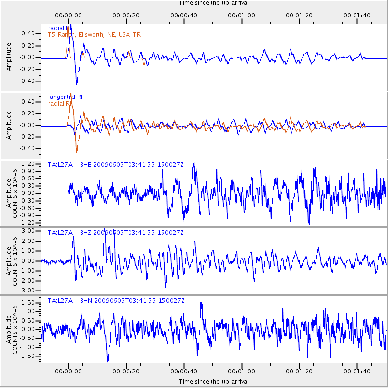
Signal To Noise
| Channel | StoN | STA | LTA |
| TA:L27A: :BHZ:20090605T03:41:55.150027Z | 9.339513 | 1.0325471E-6 | 1.1055685E-7 |
| TA:L27A: :BHN:20090605T03:41:55.150027Z | 1.9112772 | 3.7173945E-7 | 1.9449793E-7 |
| TA:L27A: :BHE:20090605T03:41:55.150027Z | 1.7269752 | 3.7345782E-7 | 2.1624967E-7 |
| Arrivals |
| Ps | 5.7 SECOND |
| PpPs | 22 SECOND |
| PsPs/PpSs | 28 SECOND |


