You are here: Home > Network List > TS - TERRAscope (Southern California Seismic Network) Stations List
> Station CALB Calabasas, California, USA > Earthquake Result Viewer
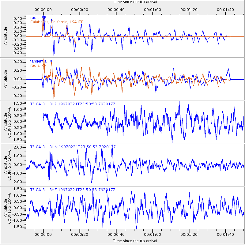
CALB Calabasas, California, USA - Earthquake Result Viewer
*The percent match for this event was below the threshold and hence no stack was calculated.
| Earthquake location: |
East Of Kuril Islands |
| Earthquake latitude/longitude: |
43.8/149.2 |
| Earthquake time(UTC): |
1997/02/21 (052) 23:40:24 GMT |
| Earthquake Depth: |
33 km |
| Earthquake Magnitude: |
6.1 MB, 5.6 MS, 6.1 UNKNOWN, 6.1 MW |
| Earthquake Catalog/Contributor: |
WHDF/NEIC |
|
| Network: |
TS TERRAscope (Southern California Seismic Network) |
| Station: |
CALB Calabasas, California, USA |
| Lat/Lon: |
34.14 N/118.63 W |
| Elevation: |
0.0 m |
|
| Distance: |
68.8 deg |
| Az: |
62.776 deg |
| Baz: |
309.109 deg |
| Ray Param: |
$rayparam |
*The percent match for this event was below the threshold and hence was not used in the summary stack. |
|
| Radial Match: |
65.267944 % |
| Radial Bump: |
400 |
| Transverse Match: |
65.5123 % |
| Transverse Bump: |
400 |
| SOD ConfigId: |
4480 |
| Insert Time: |
2010-02-26 14:03:17.107 +0000 |
| GWidth: |
2.5 |
| Max Bumps: |
400 |
| Tol: |
0.001 |
|
Signal To Noise
| Channel | StoN | STA | LTA |
| TS:CALB: :BHN:19970221T23:50:53.792017Z | 1.9039524 | 7.326768E-7 | 3.848189E-7 |
| TS:CALB: :BHE:19970221T23:50:53.792017Z | 0.6695737 | 3.3115106E-7 | 4.9457003E-7 |
| TS:CALB: :BHZ:19970221T23:50:53.792017Z | 0.8271701 | 3.134946E-7 | 3.7899656E-7 |
| Arrivals |
| Ps | |
| PpPs | |
| PsPs/PpSs | |


