You are here: Home > Network List > TA - USArray Transportable Network (new EarthScope stations) Stations List
> Station L27A T5 Ranch, Ellsworth, NE, USA > Earthquake Result Viewer
L27A T5 Ranch, Ellsworth, NE, USA - Earthquake Result Viewer
| Earthquake location: |
Southern Peru |
| Earthquake latitude/longitude: |
-15.0/-70.4 |
| Earthquake time(UTC): |
2009/07/12 (193) 06:12:47 GMT |
| Earthquake Depth: |
199 km |
| Earthquake Magnitude: |
5.7 MB, 6.1 MW, 6.1 MW |
| Earthquake Catalog/Contributor: |
WHDF/NEIC |
|
| Network: |
TA USArray Transportable Network (new EarthScope stations) |
| Station: |
L27A T5 Ranch, Ellsworth, NE, USA |
| Lat/Lon: |
42.08 N/102.32 W |
| Elevation: |
1186 m |
|
| Distance: |
64.0 deg |
| Az: |
334.065 deg |
| Baz: |
145.413 deg |
| Ray Param: |
0.058621973 |
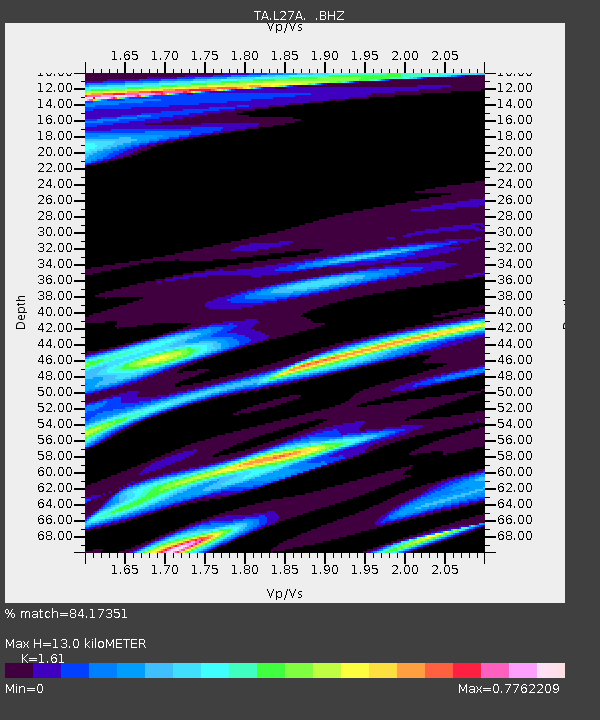
| Estimated Moho Depth: |
13.0 km |
| Estimated Crust Vp/Vs: |
1.61 |
| Assumed Crust Vp: |
6.483 km/s |
| Estimated Crust Vs: |
4.026 km/s |
| Estimated Crust Poisson's Ratio: |
0.19 |
|
| Radial Match: |
84.17351 % |
| Radial Bump: |
378 |
| Transverse Match: |
72.17064 % |
| Transverse Bump: |
400 |
| SOD ConfigId: |
2648 |
| Insert Time: |
2010-03-06 19:09:48.534 +0000 |
| GWidth: |
2.5 |
| Max Bumps: |
400 |
| Tol: |
0.001 |
|
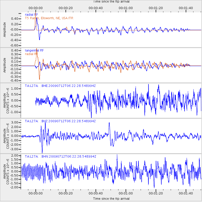
Signal To Noise
| Channel | StoN | STA | LTA |
| TA:L27A: :BHZ:20090712T06:22:28.548994Z | 9.329383 | 1.1543113E-6 | 1.2372858E-7 |
| TA:L27A: :BHN:20090712T06:22:28.548994Z | 1.2764636 | 5.6365076E-7 | 4.4157215E-7 |
| TA:L27A: :BHE:20090712T06:22:28.548994Z | 1.2908171 | 2.6853326E-7 | 2.0803354E-7 |
| Arrivals |
| Ps | 1.3 SECOND |
| PpPs | 5.0 SECOND |
| PsPs/PpSs | 6.3 SECOND |


