You are here: Home > Network List > IU - Global Seismograph Network (GSN - IRIS/USGS) Stations List
> Station XMAS Kiritimati Island, Republic of Kiribati > Earthquake Result Viewer
XMAS Kiritimati Island, Republic of Kiribati - Earthquake Result Viewer
*The percent match for this event was below the threshold and hence no stack was calculated.
| Earthquake location: |
Off E. Coast Of N. Island, N.Z. |
| Earthquake latitude/longitude: |
-37.1/178.9 |
| Earthquake time(UTC): |
2016/09/05 (249) 15:18:59 GMT |
| Earthquake Depth: |
10 km |
| Earthquake Magnitude: |
5.8 MB |
| Earthquake Catalog/Contributor: |
NEIC PDE/NEIC COMCAT |
|
| Network: |
IU Global Seismograph Network (GSN - IRIS/USGS) |
| Station: |
XMAS Kiritimati Island, Republic of Kiribati |
| Lat/Lon: |
2.04 N/157.45 W |
| Elevation: |
20 m |
|
| Distance: |
44.7 deg |
| Az: |
34.704 deg |
| Baz: |
207.092 deg |
| Ray Param: |
$rayparam |
*The percent match for this event was below the threshold and hence was not used in the summary stack. |
|
| Radial Match: |
53.389835 % |
| Radial Bump: |
400 |
| Transverse Match: |
60.720642 % |
| Transverse Bump: |
400 |
| SOD ConfigId: |
1634031 |
| Insert Time: |
2016-09-19 15:20:36.430 +0000 |
| GWidth: |
2.5 |
| Max Bumps: |
400 |
| Tol: |
0.001 |
|
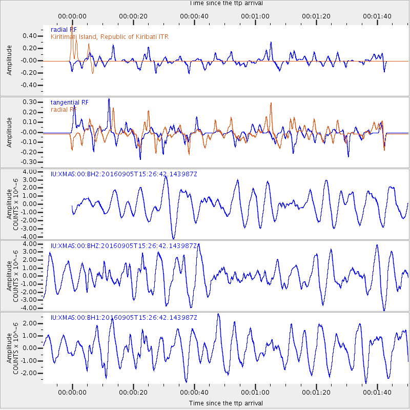
Signal To Noise
| Channel | StoN | STA | LTA |
| IU:XMAS:00:BHZ:20160905T15:26:42.143987Z | 0.8678401 | 1.1784114E-6 | 1.3578668E-6 |
| IU:XMAS:00:BH1:20160905T15:26:42.143987Z | 0.43224868 | 5.771774E-7 | 1.3352901E-6 |
| IU:XMAS:00:BH2:20160905T15:26:42.143987Z | 2.7451541 | 2.5989686E-6 | 9.4674783E-7 |
| Arrivals |
| Ps | |
| PpPs | |
| PsPs/PpSs | |


