You are here: Home > Network List > TA - USArray Transportable Network (new EarthScope stations) Stations List
> Station L26A Underwood Farm, Alliance, NE, USA > Earthquake Result Viewer
L26A Underwood Farm, Alliance, NE, USA - Earthquake Result Viewer
| Earthquake location: |
South Of Panama |
| Earthquake latitude/longitude: |
5.7/-82.8 |
| Earthquake time(UTC): |
2009/03/12 (071) 23:23:34 GMT |
| Earthquake Depth: |
9.0 km |
| Earthquake Magnitude: |
6.1 MB, 5.9 MS, 6.3 MW, 6.2 MW |
| Earthquake Catalog/Contributor: |
WHDF/NEIC |
|
| Network: |
TA USArray Transportable Network (new EarthScope stations) |
| Station: |
L26A Underwood Farm, Alliance, NE, USA |
| Lat/Lon: |
42.04 N/103.08 W |
| Elevation: |
1248 m |
|
| Distance: |
40.5 deg |
| Az: |
336.513 deg |
| Baz: |
147.833 deg |
| Ray Param: |
0.07439367 |
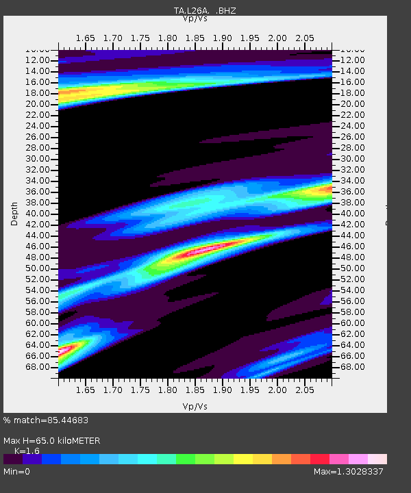
| Estimated Moho Depth: |
65.0 km |
| Estimated Crust Vp/Vs: |
1.60 |
| Assumed Crust Vp: |
6.483 km/s |
| Estimated Crust Vs: |
4.052 km/s |
| Estimated Crust Poisson's Ratio: |
0.18 |
|
| Radial Match: |
85.44683 % |
| Radial Bump: |
294 |
| Transverse Match: |
81.01912 % |
| Transverse Bump: |
400 |
| SOD ConfigId: |
2658 |
| Insert Time: |
2010-03-06 19:10:40.212 +0000 |
| GWidth: |
2.5 |
| Max Bumps: |
400 |
| Tol: |
0.001 |
|

Signal To Noise
| Channel | StoN | STA | LTA |
| TA:L26A: :BHZ:20090312T23:30:42.723992Z | 13.72298 | 3.1604848E-6 | 2.3030601E-7 |
| TA:L26A: :BHN:20090312T23:30:42.723992Z | 2.0365136 | 8.550712E-7 | 4.1987013E-7 |
| TA:L26A: :BHE:20090312T23:30:42.723992Z | 1.8801627 | 7.5632687E-7 | 4.0226672E-7 |
| Arrivals |
| Ps | 6.5 SECOND |
| PpPs | 24 SECOND |
| PsPs/PpSs | 31 SECOND |


