You are here: Home > Network List > TA - USArray Transportable Network (new EarthScope stations) Stations List
> Station L26A Underwood Farm, Alliance, NE, USA > Earthquake Result Viewer
L26A Underwood Farm, Alliance, NE, USA - Earthquake Result Viewer
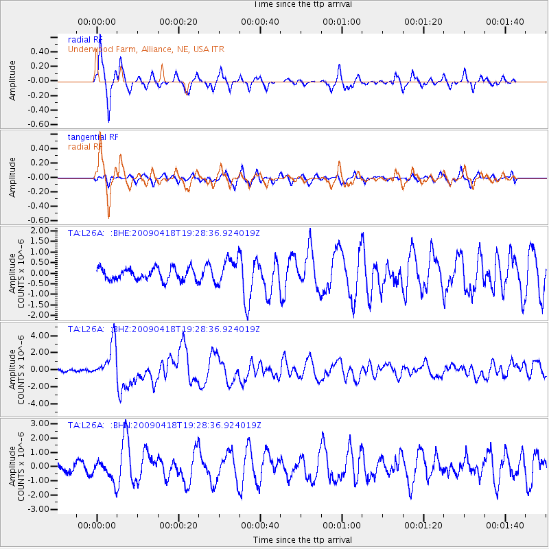
| Earthquake location: |
Kuril Islands |
| Earthquake latitude/longitude: |
46.0/151.4 |
| Earthquake time(UTC): |
2009/04/18 (108) 19:17:58 GMT |
| Earthquake Depth: |
35 km |
| Earthquake Magnitude: |
6.3 MB, 6.3 MS, 6.6 MW, 6.4 MW |
| Earthquake Catalog/Contributor: |
WHDF/NEIC |
|
| Network: |
TA USArray Transportable Network (new EarthScope stations) |
| Station: |
L26A Underwood Farm, Alliance, NE, USA |
| Lat/Lon: |
42.04 N/103.08 W |
| Elevation: |
1248 m |
|
| Distance: |
70.1 deg |
| Az: |
49.755 deg |
| Baz: |
314.436 deg |
| Ray Param: |
0.055127777 |
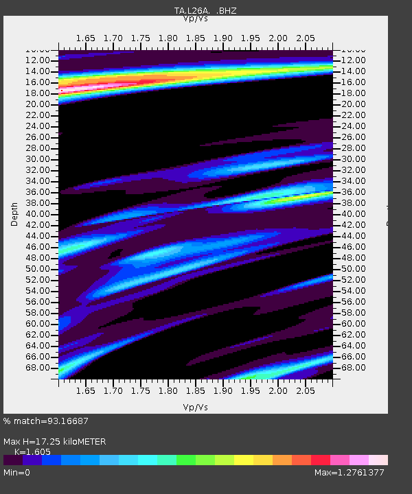
| Estimated Moho Depth: |
17.25 km |
| Estimated Crust Vp/Vs: |
1.61 |
| Assumed Crust Vp: |
6.483 km/s |
| Estimated Crust Vs: |
4.039 km/s |
| Estimated Crust Poisson's Ratio: |
0.18 |
|
| Radial Match: |
93.16687 % |
| Radial Bump: |
333 |
| Transverse Match: |
68.90532 % |
| Transverse Bump: |
400 |
| SOD ConfigId: |
2760 |
| Insert Time: |
2010-03-06 19:10:53.187 +0000 |
| GWidth: |
2.5 |
| Max Bumps: |
400 |
| Tol: |
0.001 |
|
Signal To Noise
| Channel | StoN | STA | LTA |
| TA:L26A: :BHZ:20090418T19:28:36.924019Z | 16.772648 | 2.1969481E-6 | 1.3098398E-7 |
| TA:L26A: :BHN:20090418T19:28:36.924019Z | 1.5965718 | 7.280232E-7 | 4.5599154E-7 |
| TA:L26A: :BHE:20090418T19:28:36.924019Z | 2.2830992 | 6.313297E-7 | 2.7652314E-7 |
| Arrivals |
| Ps | 1.7 SECOND |
| PpPs | 6.6 SECOND |
| PsPs/PpSs | 8.3 SECOND |


