You are here: Home > Network List > TA - USArray Transportable Network (new EarthScope stations) Stations List
> Station L26A Underwood Farm, Alliance, NE, USA > Earthquake Result Viewer
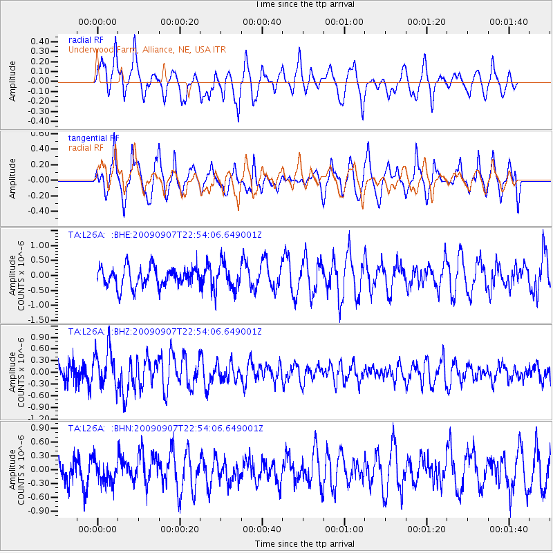
L26A Underwood Farm, Alliance, NE, USA - Earthquake Result Viewer
*The percent match for this event was below the threshold and hence no stack was calculated.
| Earthquake location: |
Northwestern Caucasus |
| Earthquake latitude/longitude: |
42.7/43.4 |
| Earthquake time(UTC): |
2009/09/07 (250) 22:41:37 GMT |
| Earthquake Depth: |
15 km |
| Earthquake Magnitude: |
5.7 MB, 5.8 MS, 6.0 MW, 5.9 MW |
| Earthquake Catalog/Contributor: |
WHDF/NEIC |
|
| Network: |
TA USArray Transportable Network (new EarthScope stations) |
| Station: |
L26A Underwood Farm, Alliance, NE, USA |
| Lat/Lon: |
42.04 N/103.08 W |
| Elevation: |
1248 m |
|
| Distance: |
90.5 deg |
| Az: |
335.737 deg |
| Baz: |
24.011 deg |
| Ray Param: |
$rayparam |
*The percent match for this event was below the threshold and hence was not used in the summary stack. |
|
| Radial Match: |
59.29783 % |
| Radial Bump: |
400 |
| Transverse Match: |
64.17133 % |
| Transverse Bump: |
400 |
| SOD ConfigId: |
2622 |
| Insert Time: |
2010-03-06 19:11:06.660 +0000 |
| GWidth: |
2.5 |
| Max Bumps: |
400 |
| Tol: |
0.001 |
|
Signal To Noise
| Channel | StoN | STA | LTA |
| TA:L26A: :BHZ:20090907T22:54:06.649001Z | 1.8602011 | 4.936399E-7 | 2.653691E-7 |
| TA:L26A: :BHN:20090907T22:54:06.649001Z | 0.5211441 | 2.421173E-7 | 4.6458803E-7 |
| TA:L26A: :BHE:20090907T22:54:06.649001Z | 1.3093363 | 4.2595738E-7 | 3.2532313E-7 |
| Arrivals |
| Ps | |
| PpPs | |
| PsPs/PpSs | |


