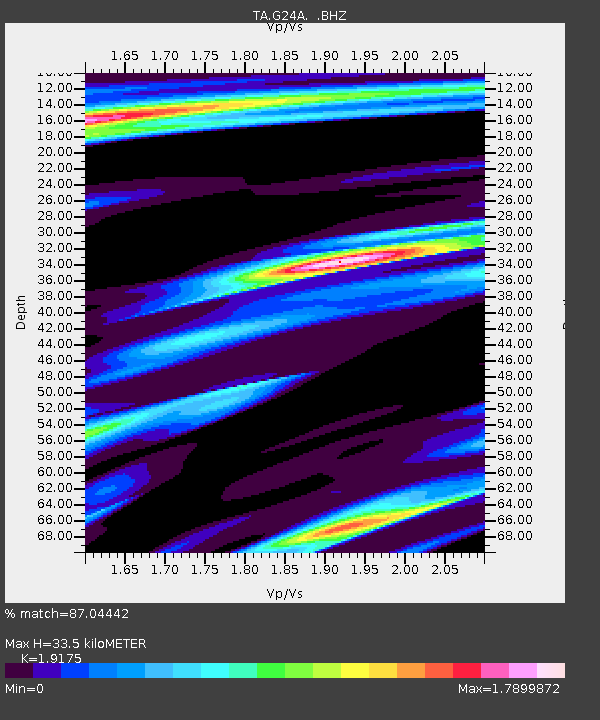
G24A Alzada, MT, USA - Earthquake Result Viewer
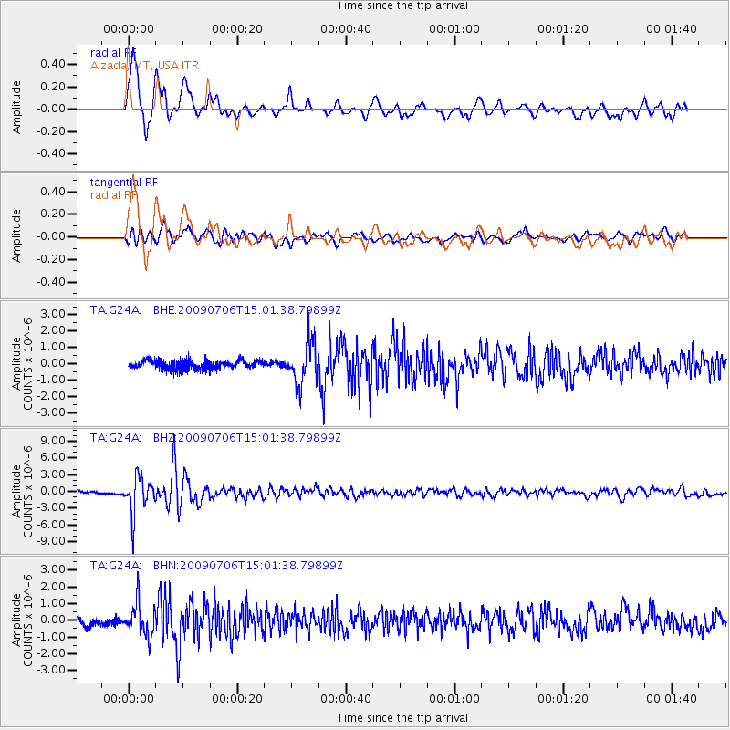
Earthquake location: Rat Islands, Aleutian Islands
Earthquake latitude/longitude: 50.4/177.0
Earthquake time(UTC): 2009/07/06 (187) 14:53:12 GMT
Earthquake Depth: 22 km
Earthquake Magnitude: 6.0 MB, 5.8 MS, 6.1 MW, 6.0 MW
Earthquake Catalog/Contributor: WHDF/NEIC
Network: TA USArray Transportable Network (new EarthScope stations)
Station: G24A Alzada, MT, USA
Lat/Lon: 45.33 N/104.42 W
Elevation: 1147 m
Distance: 50.6 deg
Az: 63.419 deg
Baz: 305.834 deg
Ray Param: 0.067885846
Estimated Moho Depth: 33.5 km
Estimated Crust Vp/Vs: 1.92
Assumed Crust Vp: 6.242 km/s
Estimated Crust Vs: 3.255 km/s
Estimated Crust Poisson's Ratio: 0.31
Radial Match: 87.04442 %
Radial Bump: 400
Transverse Match: 73.08306 %
Transverse Bump: 400
SOD ConfigId: 2648
Insert Time: 2010-03-06 19:12:16.480 +0000
GWidth: 2.5
Max Bumps: 400
Tol: 0.001

Signal To Noise

ChannelStoNSTALTA
TA:G24A: :BHZ:20090706T15:01:38.79899Z14.0231633.2898054E-62.3459795E-7
TA:G24A: :BHN:20090706T15:01:38.79899Z3.6810319.850821E-72.6761037E-7
TA:G24A: :BHE:20090706T15:01:38.79899Z5.22594171.3893679E-62.6585982E-7
Arrivals
Ps5.2 SECOND
PpPs15 SECOND
PsPs/PpSs20 SECOND