You are here: Home > Network List > TA - USArray Transportable Network (new EarthScope stations) Stations List
> Station G24A Alzada, MT, USA > Earthquake Result Viewer
G24A Alzada, MT, USA - Earthquake Result Viewer
| Earthquake location: |
Baffin Bay |
| Earthquake latitude/longitude: |
75.4/-72.5 |
| Earthquake time(UTC): |
2009/07/07 (188) 19:11:46 GMT |
| Earthquake Depth: |
19 km |
| Earthquake Magnitude: |
5.9 MB, 5.7 MS, 6.1 MW, 6.0 MW |
| Earthquake Catalog/Contributor: |
WHDF/NEIC |
|
| Network: |
TA USArray Transportable Network (new EarthScope stations) |
| Station: |
G24A Alzada, MT, USA |
| Lat/Lon: |
45.33 N/104.42 W |
| Elevation: |
1147 m |
|
| Distance: |
33.1 deg |
| Az: |
223.148 deg |
| Baz: |
14.283 deg |
| Ray Param: |
0.078345746 |
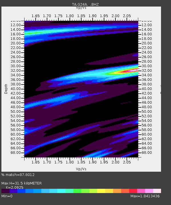
| Estimated Moho Depth: |
31.5 km |
| Estimated Crust Vp/Vs: |
2.09 |
| Assumed Crust Vp: |
6.242 km/s |
| Estimated Crust Vs: |
2.983 km/s |
| Estimated Crust Poisson's Ratio: |
0.35 |
|
| Radial Match: |
87.8012 % |
| Radial Bump: |
345 |
| Transverse Match: |
67.56928 % |
| Transverse Bump: |
400 |
| SOD ConfigId: |
2648 |
| Insert Time: |
2010-03-06 19:12:18.249 +0000 |
| GWidth: |
2.5 |
| Max Bumps: |
400 |
| Tol: |
0.001 |
|
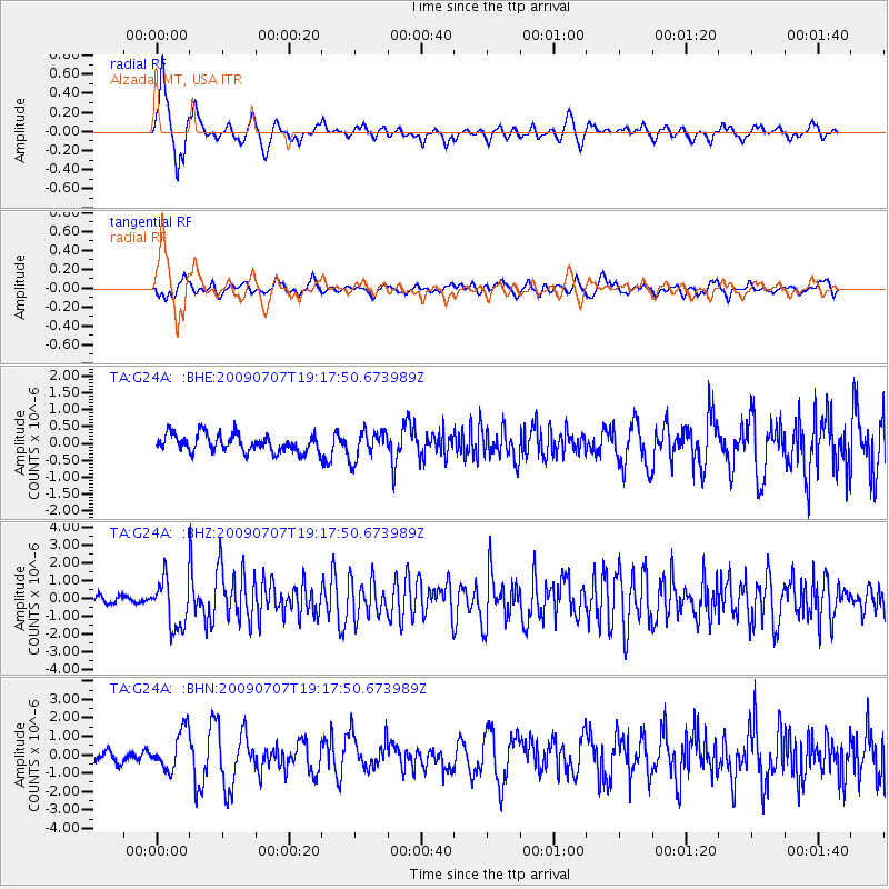
Signal To Noise
| Channel | StoN | STA | LTA |
| TA:G24A: :BHZ:20090707T19:17:50.673989Z | 7.2523847 | 1.3570698E-6 | 1.8712049E-7 |
| TA:G24A: :BHN:20090707T19:17:50.673989Z | 4.1327662 | 1.0770304E-6 | 2.6060766E-7 |
| TA:G24A: :BHE:20090707T19:17:50.673989Z | 1.6197355 | 4.1633612E-7 | 2.5703957E-7 |
| Arrivals |
| Ps | 5.9 SECOND |
| PpPs | 15 SECOND |
| PsPs/PpSs | 21 SECOND |


