You are here: Home > Network List > TA - USArray Transportable Network (new EarthScope stations) Stations List
> Station G24A Alzada, MT, USA > Earthquake Result Viewer
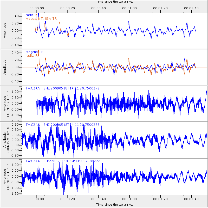
G24A Alzada, MT, USA - Earthquake Result Viewer
*The percent match for this event was below the threshold and hence no stack was calculated.
| Earthquake location: |
Near Coast Of Peru |
| Earthquake latitude/longitude: |
-15.7/-74.8 |
| Earthquake time(UTC): |
2009/05/18 (138) 14:01:04 GMT |
| Earthquake Depth: |
23 km |
| Earthquake Magnitude: |
5.5 MS, 5.3 MB, 5.8 MW, 5.8 MW |
| Earthquake Catalog/Contributor: |
WHDF/NEIC |
|
| Network: |
TA USArray Transportable Network (new EarthScope stations) |
| Station: |
G24A Alzada, MT, USA |
| Lat/Lon: |
45.33 N/104.42 W |
| Elevation: |
1147 m |
|
| Distance: |
66.4 deg |
| Az: |
337.661 deg |
| Baz: |
148.73 deg |
| Ray Param: |
$rayparam |
*The percent match for this event was below the threshold and hence was not used in the summary stack. |
|
| Radial Match: |
57.23715 % |
| Radial Bump: |
338 |
| Transverse Match: |
36.92828 % |
| Transverse Bump: |
341 |
| SOD ConfigId: |
2760 |
| Insert Time: |
2010-03-06 19:12:28.432 +0000 |
| GWidth: |
2.5 |
| Max Bumps: |
400 |
| Tol: |
0.001 |
|
Signal To Noise
| Channel | StoN | STA | LTA |
| TA:G24A: :BHZ:20090518T14:11:20.750027Z | 1.7057543 | 4.2242004E-7 | 2.4764415E-7 |
| TA:G24A: :BHN:20090518T14:11:20.750027Z | 0.8751041 | 3.4974434E-7 | 3.9966028E-7 |
| TA:G24A: :BHE:20090518T14:11:20.750027Z | 0.955723 | 3.7912267E-7 | 3.9668677E-7 |
| Arrivals |
| Ps | |
| PpPs | |
| PsPs/PpSs | |


