You are here: Home > Network List > N4 - Central and EAstern US Network Stations List
> Station L46A Eue Claire, MI, USA > Earthquake Result Viewer
L46A Eue Claire, MI, USA - Earthquake Result Viewer
| Earthquake location: |
Western Brazil |
| Earthquake latitude/longitude: |
-8.1/-71.6 |
| Earthquake time(UTC): |
2019/01/05 (005) 19:25:38 GMT |
| Earthquake Depth: |
575 km |
| Earthquake Magnitude: |
6.8 Mww |
| Earthquake Catalog/Contributor: |
NEIC PDE/us |
|
| Network: |
N4 Central and EAstern US Network |
| Station: |
L46A Eue Claire, MI, USA |
| Lat/Lon: |
42.01 N/86.30 W |
| Elevation: |
223 m |
|
| Distance: |
51.7 deg |
| Az: |
346.036 deg |
| Baz: |
161.301 deg |
| Ray Param: |
0.06463884 |
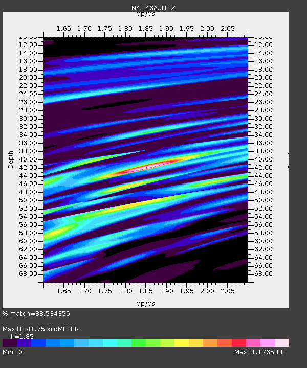
| Estimated Moho Depth: |
41.75 km |
| Estimated Crust Vp/Vs: |
1.85 |
| Assumed Crust Vp: |
6.483 km/s |
| Estimated Crust Vs: |
3.504 km/s |
| Estimated Crust Poisson's Ratio: |
0.29 |
|
| Radial Match: |
88.534355 % |
| Radial Bump: |
400 |
| Transverse Match: |
52.912254 % |
| Transverse Bump: |
400 |
| SOD ConfigId: |
13570011 |
| Insert Time: |
2019-05-02 06:15:32.512 +0000 |
| GWidth: |
2.5 |
| Max Bumps: |
400 |
| Tol: |
0.001 |
|

Signal To Noise
| Channel | StoN | STA | LTA |
| N4:L46A: :HHZ:20190105T19:33:22.759998Z | 14.786542 | 1.10088395E-5 | 7.4451754E-7 |
| N4:L46A: :HHN:20190105T19:33:22.759998Z | 16.628984 | 7.79491E-6 | 4.6875442E-7 |
| N4:L46A: :HHE:20190105T19:33:22.759998Z | 9.756955 | 6.1263895E-6 | 6.2789974E-7 |
| Arrivals |
| Ps | 5.8 SECOND |
| PpPs | 17 SECOND |
| PsPs/PpSs | 23 SECOND |


