You are here: Home > Network List > TA - USArray Transportable Network (new EarthScope stations) Stations List
> Station G24A Alzada, MT, USA > Earthquake Result Viewer
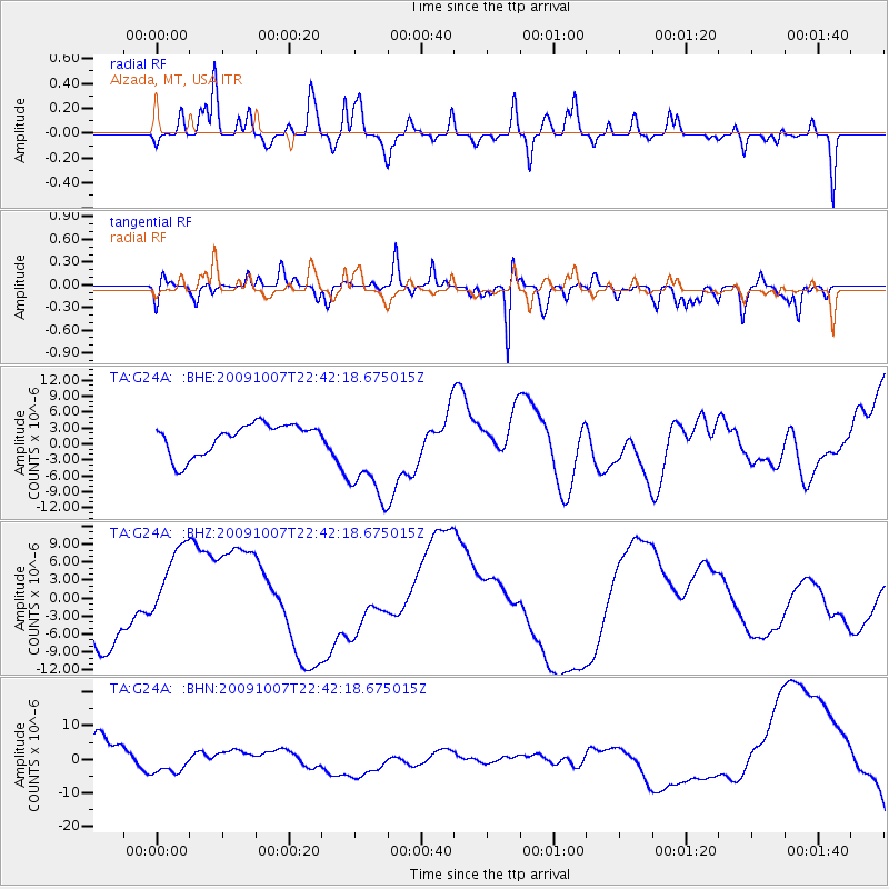
G24A Alzada, MT, USA - Earthquake Result Viewer
*The percent match for this event was below the threshold and hence no stack was calculated.
| Earthquake location: |
Santa Cruz Islands |
| Earthquake latitude/longitude: |
-11.5/166.0 |
| Earthquake time(UTC): |
2009/10/07 (280) 22:29:18 GMT |
| Earthquake Depth: |
35 km |
| Earthquake Magnitude: |
5.5 MB |
| Earthquake Catalog/Contributor: |
WHDF/NEIC |
|
| Network: |
TA USArray Transportable Network (new EarthScope stations) |
| Station: |
G24A Alzada, MT, USA |
| Lat/Lon: |
45.33 N/104.42 W |
| Elevation: |
1147 m |
|
| Distance: |
97.8 deg |
| Az: |
45.393 deg |
| Baz: |
261.572 deg |
| Ray Param: |
$rayparam |
*The percent match for this event was below the threshold and hence was not used in the summary stack. |
|
| Radial Match: |
60.06384 % |
| Radial Bump: |
400 |
| Transverse Match: |
65.30375 % |
| Transverse Bump: |
400 |
| SOD ConfigId: |
2622 |
| Insert Time: |
2010-03-06 19:12:45.712 +0000 |
| GWidth: |
2.5 |
| Max Bumps: |
400 |
| Tol: |
0.001 |
|
Signal To Noise
| Channel | StoN | STA | LTA |
| TA:G24A: :BHZ:20091007T22:42:18.675015Z | 1.4310167 | 7.903711E-6 | 5.5231435E-6 |
| TA:G24A: :BHN:20091007T22:42:18.675015Z | 0.6357155 | 2.6300868E-6 | 4.1372073E-6 |
| TA:G24A: :BHE:20091007T22:42:18.675015Z | 3.2153006 | 9.321196E-6 | 2.8990123E-6 |
| Arrivals |
| Ps | |
| PpPs | |
| PsPs/PpSs | |


