You are here: Home > Network List > N4 - Central and EAstern US Network Stations List
> Station P48A Milroy, IN, USA > Earthquake Result Viewer
P48A Milroy, IN, USA - Earthquake Result Viewer
| Earthquake location: |
Western Brazil |
| Earthquake latitude/longitude: |
-8.1/-71.6 |
| Earthquake time(UTC): |
2019/01/05 (005) 19:25:38 GMT |
| Earthquake Depth: |
575 km |
| Earthquake Magnitude: |
6.8 Mww |
| Earthquake Catalog/Contributor: |
NEIC PDE/us |
|
| Network: |
N4 Central and EAstern US Network |
| Station: |
P48A Milroy, IN, USA |
| Lat/Lon: |
39.46 N/85.43 W |
| Elevation: |
300 m |
|
| Distance: |
49.1 deg |
| Az: |
345.8 deg |
| Baz: |
161.716 deg |
| Ray Param: |
0.066252165 |
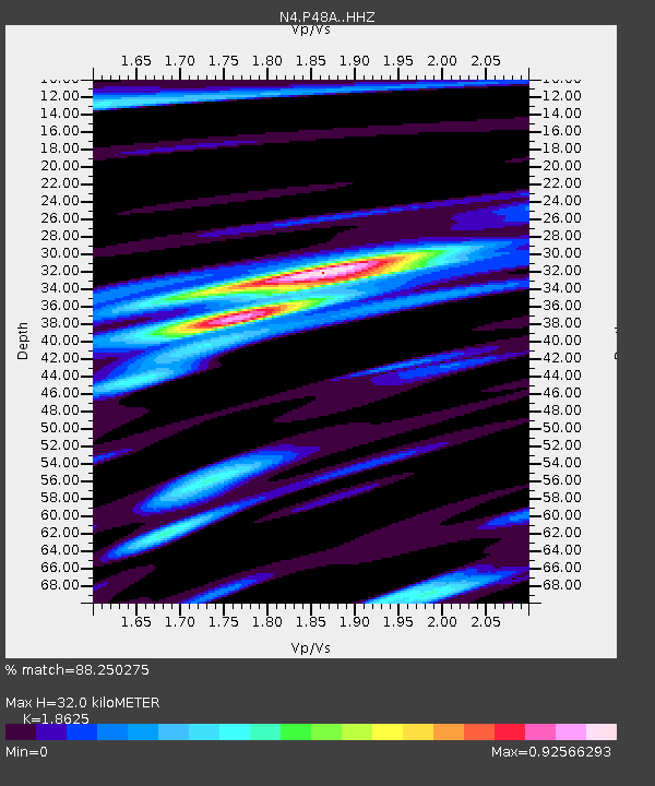
| Estimated Moho Depth: |
32.0 km |
| Estimated Crust Vp/Vs: |
1.86 |
| Assumed Crust Vp: |
6.498 km/s |
| Estimated Crust Vs: |
3.489 km/s |
| Estimated Crust Poisson's Ratio: |
0.30 |
|
| Radial Match: |
88.250275 % |
| Radial Bump: |
400 |
| Transverse Match: |
63.909565 % |
| Transverse Bump: |
400 |
| SOD ConfigId: |
13570011 |
| Insert Time: |
2019-05-02 06:15:56.287 +0000 |
| GWidth: |
2.5 |
| Max Bumps: |
400 |
| Tol: |
0.001 |
|

Signal To Noise
| Channel | StoN | STA | LTA |
| N4:P48A: :HHZ:20190105T19:33:03.68999Z | 17.834993 | 9.729496E-6 | 5.4552845E-7 |
| N4:P48A: :HHN:20190105T19:33:03.68999Z | 10.648011 | 5.3506765E-6 | 5.025048E-7 |
| N4:P48A: :HHE:20190105T19:33:03.68999Z | 6.539645 | 1.810144E-6 | 2.7679545E-7 |
| Arrivals |
| Ps | 4.5 SECOND |
| PpPs | 13 SECOND |
| PsPs/PpSs | 18 SECOND |


