You are here: Home > Network List > N4 - Central and EAstern US Network Stations List
> Station T57A Hurt, VA, USA > Earthquake Result Viewer
T57A Hurt, VA, USA - Earthquake Result Viewer
| Earthquake location: |
Western Brazil |
| Earthquake latitude/longitude: |
-8.1/-71.6 |
| Earthquake time(UTC): |
2019/01/05 (005) 19:25:38 GMT |
| Earthquake Depth: |
575 km |
| Earthquake Magnitude: |
6.8 Mww |
| Earthquake Catalog/Contributor: |
NEIC PDE/us |
|
| Network: |
N4 Central and EAstern US Network |
| Station: |
T57A Hurt, VA, USA |
| Lat/Lon: |
37.00 N/79.25 W |
| Elevation: |
230 m |
|
| Distance: |
45.5 deg |
| Az: |
351.369 deg |
| Baz: |
169.305 deg |
| Ray Param: |
0.06843875 |
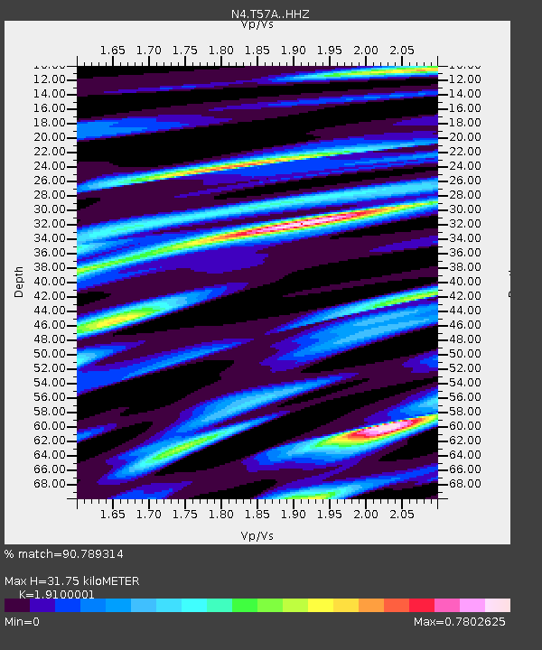
| Estimated Moho Depth: |
31.75 km |
| Estimated Crust Vp/Vs: |
1.91 |
| Assumed Crust Vp: |
6.419 km/s |
| Estimated Crust Vs: |
3.361 km/s |
| Estimated Crust Poisson's Ratio: |
0.31 |
|
| Radial Match: |
90.789314 % |
| Radial Bump: |
298 |
| Transverse Match: |
78.65246 % |
| Transverse Bump: |
400 |
| SOD ConfigId: |
13570011 |
| Insert Time: |
2019-05-02 06:16:17.503 +0000 |
| GWidth: |
2.5 |
| Max Bumps: |
400 |
| Tol: |
0.001 |
|

Signal To Noise
| Channel | StoN | STA | LTA |
| N4:T57A: :HHZ:20190105T19:32:36.809985Z | 29.623058 | 1.604073E-5 | 5.414947E-7 |
| N4:T57A: :HHN:20190105T19:32:36.809985Z | 23.039331 | 1.0011743E-5 | 4.3455006E-7 |
| N4:T57A: :HHE:20190105T19:32:36.809985Z | 8.361249 | 2.5299005E-6 | 3.0257445E-7 |
| Arrivals |
| Ps | 4.8 SECOND |
| PpPs | 14 SECOND |
| PsPs/PpSs | 18 SECOND |


