You are here: Home > Network List > TA - USArray Transportable Network (new EarthScope stations) Stations List
> Station G24A Alzada, MT, USA > Earthquake Result Viewer
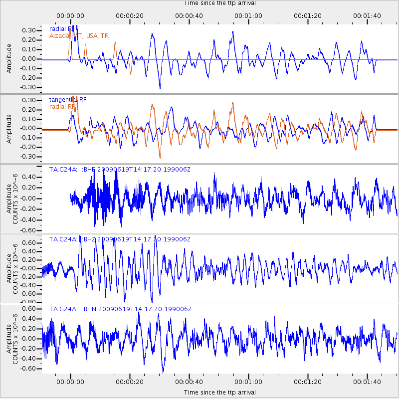
G24A Alzada, MT, USA - Earthquake Result Viewer
*The percent match for this event was below the threshold and hence no stack was calculated.
| Earthquake location: |
Eastern Mediterranean Sea |
| Earthquake latitude/longitude: |
35.4/28.5 |
| Earthquake time(UTC): |
2009/06/19 (170) 14:04:59 GMT |
| Earthquake Depth: |
28 km |
| Earthquake Magnitude: |
5.6 MB, 5.6 MS, 5.8 MW, 5.8 MW |
| Earthquake Catalog/Contributor: |
WHDF/NEIC |
|
| Network: |
TA USArray Transportable Network (new EarthScope stations) |
| Station: |
G24A Alzada, MT, USA |
| Lat/Lon: |
45.33 N/104.42 W |
| Elevation: |
1147 m |
|
| Distance: |
89.1 deg |
| Az: |
328.863 deg |
| Baz: |
36.808 deg |
| Ray Param: |
$rayparam |
*The percent match for this event was below the threshold and hence was not used in the summary stack. |
|
| Radial Match: |
64.017006 % |
| Radial Bump: |
400 |
| Transverse Match: |
46.56253 % |
| Transverse Bump: |
400 |
| SOD ConfigId: |
2648 |
| Insert Time: |
2010-03-06 19:13:08.909 +0000 |
| GWidth: |
2.5 |
| Max Bumps: |
400 |
| Tol: |
0.001 |
|
Signal To Noise
| Channel | StoN | STA | LTA |
| TA:G24A: :BHZ:20090619T14:17:20.199006Z | 2.5115273 | 3.1984976E-7 | 1.2735269E-7 |
| TA:G24A: :BHN:20090619T14:17:20.199006Z | 0.6245798 | 1.3318392E-7 | 2.1323764E-7 |
| TA:G24A: :BHE:20090619T14:17:20.199006Z | 0.90530133 | 1.5972918E-7 | 1.764376E-7 |
| Arrivals |
| Ps | |
| PpPs | |
| PsPs/PpSs | |


