You are here: Home > Network List > TA - USArray Transportable Network (new EarthScope stations) Stations List
> Station 833A Chaparral WMA, Artesia Wells, TX, USA > Earthquake Result Viewer
833A Chaparral WMA, Artesia Wells, TX, USA - Earthquake Result Viewer
| Earthquake location: |
Western Brazil |
| Earthquake latitude/longitude: |
-8.1/-71.6 |
| Earthquake time(UTC): |
2019/01/05 (005) 19:25:38 GMT |
| Earthquake Depth: |
575 km |
| Earthquake Magnitude: |
6.8 Mww |
| Earthquake Catalog/Contributor: |
NEIC PDE/us |
|
| Network: |
TA USArray Transportable Network (new EarthScope stations) |
| Station: |
833A Chaparral WMA, Artesia Wells, TX, USA |
| Lat/Lon: |
28.32 N/99.39 W |
| Elevation: |
171 m |
|
| Distance: |
45.1 deg |
| Az: |
324.508 deg |
| Baz: |
139.307 deg |
| Ray Param: |
0.0686462 |
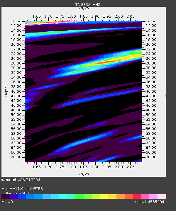
| Estimated Moho Depth: |
11.0 km |
| Estimated Crust Vp/Vs: |
1.62 |
| Assumed Crust Vp: |
6.347 km/s |
| Estimated Crust Vs: |
3.924 km/s |
| Estimated Crust Poisson's Ratio: |
0.19 |
|
| Radial Match: |
86.718796 % |
| Radial Bump: |
400 |
| Transverse Match: |
73.86476 % |
| Transverse Bump: |
400 |
| SOD ConfigId: |
13570011 |
| Insert Time: |
2019-05-02 06:18:54.506 +0000 |
| GWidth: |
2.5 |
| Max Bumps: |
400 |
| Tol: |
0.001 |
|

Signal To Noise
| Channel | StoN | STA | LTA |
| TA:833A: :HHZ:20190105T19:32:34.110004Z | 72.13989 | 1.7472039E-5 | 2.4219662E-7 |
| TA:833A: :HHN:20190105T19:32:34.110004Z | 24.561588 | 3.798051E-6 | 1.5463377E-7 |
| TA:833A: :HHE:20190105T19:32:34.110004Z | 7.6033854 | 4.189839E-6 | 5.5104914E-7 |
| Arrivals |
| Ps | 1.1 SECOND |
| PpPs | 4.3 SECOND |
| PsPs/PpSs | 5.4 SECOND |


