You are here: Home > Network List > TA - USArray Transportable Network (new EarthScope stations) Stations List
> Station Q26A Hugo, CO, USA > Earthquake Result Viewer
Q26A Hugo, CO, USA - Earthquake Result Viewer
| Earthquake location: |
Costa Rica |
| Earthquake latitude/longitude: |
10.2/-84.2 |
| Earthquake time(UTC): |
2009/01/08 (008) 19:21:35 GMT |
| Earthquake Depth: |
14 km |
| Earthquake Magnitude: |
5.7 MB, 6.0 MS, 6.1 MW, 6.1 MW |
| Earthquake Catalog/Contributor: |
WHDF/NEIC |
|
| Network: |
TA USArray Transportable Network (new EarthScope stations) |
| Station: |
Q26A Hugo, CO, USA |
| Lat/Lon: |
38.92 N/103.52 W |
| Elevation: |
1546 m |
|
| Distance: |
33.4 deg |
| Az: |
332.075 deg |
| Baz: |
143.767 deg |
| Ray Param: |
0.07819584 |
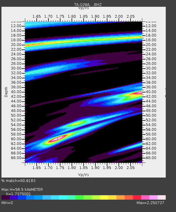
| Estimated Moho Depth: |
59.5 km |
| Estimated Crust Vp/Vs: |
1.74 |
| Assumed Crust Vp: |
6.242 km/s |
| Estimated Crust Vs: |
3.593 km/s |
| Estimated Crust Poisson's Ratio: |
0.25 |
|
| Radial Match: |
80.6193 % |
| Radial Bump: |
291 |
| Transverse Match: |
42.663624 % |
| Transverse Bump: |
308 |
| SOD ConfigId: |
2834 |
| Insert Time: |
2010-03-06 19:13:37.850 +0000 |
| GWidth: |
2.5 |
| Max Bumps: |
400 |
| Tol: |
0.001 |
|

Signal To Noise
| Channel | StoN | STA | LTA |
| TA:Q26A: :BHZ:20090108T19:27:43.250015Z | 5.513118 | 1.0344407E-6 | 1.8763262E-7 |
| TA:Q26A: :BHN:20090108T19:27:43.250015Z | 1.7639619 | 5.7364247E-7 | 3.2520117E-7 |
| TA:Q26A: :BHE:20090108T19:27:43.250015Z | 0.7292165 | 3.1831044E-7 | 4.365102E-7 |
| Arrivals |
| Ps | 7.6 SECOND |
| PpPs | 24 SECOND |
| PsPs/PpSs | 32 SECOND |


