You are here: Home > Network List > TA - USArray Transportable Network (new EarthScope stations) Stations List
> Station Q26A Hugo, CO, USA > Earthquake Result Viewer
Q26A Hugo, CO, USA - Earthquake Result Viewer
| Earthquake location: |
East Of Kuril Islands |
| Earthquake latitude/longitude: |
46.9/155.2 |
| Earthquake time(UTC): |
2009/01/15 (015) 17:49:39 GMT |
| Earthquake Depth: |
36 km |
| Earthquake Magnitude: |
6.9 MB, 7.5 MS, 7.4 MW, 7.4 MW |
| Earthquake Catalog/Contributor: |
WHDF/NEIC |
|
| Network: |
TA USArray Transportable Network (new EarthScope stations) |
| Station: |
Q26A Hugo, CO, USA |
| Lat/Lon: |
38.92 N/103.52 W |
| Elevation: |
1546 m |
|
| Distance: |
69.5 deg |
| Az: |
54.735 deg |
| Baz: |
314.083 deg |
| Ray Param: |
0.05553897 |
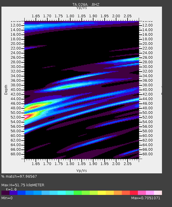
| Estimated Moho Depth: |
51.75 km |
| Estimated Crust Vp/Vs: |
1.60 |
| Assumed Crust Vp: |
6.242 km/s |
| Estimated Crust Vs: |
3.901 km/s |
| Estimated Crust Poisson's Ratio: |
0.18 |
|
| Radial Match: |
97.96567 % |
| Radial Bump: |
280 |
| Transverse Match: |
93.134254 % |
| Transverse Bump: |
400 |
| SOD ConfigId: |
2834 |
| Insert Time: |
2010-03-06 19:13:41.027 +0000 |
| GWidth: |
2.5 |
| Max Bumps: |
400 |
| Tol: |
0.001 |
|

Signal To Noise
| Channel | StoN | STA | LTA |
| TA:Q26A: :BHZ:20090115T18:00:13.150017Z | 43.653755 | 1.1913687E-5 | 2.729132E-7 |
| TA:Q26A: :BHN:20090115T18:00:13.150017Z | 5.574017 | 4.380354E-6 | 7.8585225E-7 |
| TA:Q26A: :BHE:20090115T18:00:13.150017Z | 6.7485 | 5.1770617E-6 | 7.671426E-7 |
| Arrivals |
| Ps | 5.2 SECOND |
| PpPs | 21 SECOND |
| PsPs/PpSs | 26 SECOND |


