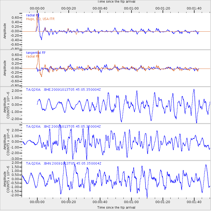
Q26A Hugo, CO, USA - Earthquake Result Viewer
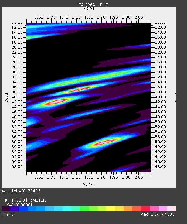
Earthquake location: Fox Islands, Aleutian Islands
Earthquake latitude/longitude: 52.8/-167.0
Earthquake time(UTC): 2009/10/13 (286) 05:37:23 GMT
Earthquake Depth: 24 km
Earthquake Magnitude: 6.0 MB, 6.1 MS, 6.5 MW, 6.5 MW
Earthquake Catalog/Contributor: WHDF/NEIC
Network: TA USArray Transportable Network (new EarthScope stations)
Station: Q26A Hugo, CO, USA
Lat/Lon: 38.92 N/103.52 W
Elevation: 1546 m
Distance: 44.9 deg
Az: 81.547 deg
Baz: 309.58 deg
Ray Param: 0.071607046
Estimated Moho Depth: 58.0 km
Estimated Crust Vp/Vs: 1.91
Assumed Crust Vp: 6.242 km/s
Estimated Crust Vs: 3.268 km/s
Estimated Crust Poisson's Ratio: 0.31
Radial Match: 81.77496 %
Radial Bump: 260
Transverse Match: 52.346672 %
Transverse Bump: 389
SOD ConfigId: 2622
Insert Time: 2010-03-06 19:13:47.386 +0000
GWidth: 2.5
Max Bumps: 400
Tol: 0.001

Signal To Noise

ChannelStoNSTALTA
TA:Q26A: :BHZ:20091013T05:45:05.350004Z3.25707175.9187516E-71.8172003E-7
TA:Q26A: :BHN:20091013T05:45:05.350004Z1.20227425.9854705E-74.978457E-7
TA:Q26A: :BHE:20091013T05:45:05.350004Z1.07554085.5809255E-75.1889486E-7
Arrivals
Ps8.9 SECOND
PpPs26 SECOND
PsPs/PpSs35 SECOND