You are here: Home > Network List > TA - USArray Transportable Network (new EarthScope stations) Stations List
> Station Q26A Hugo, CO, USA > Earthquake Result Viewer
Q26A Hugo, CO, USA - Earthquake Result Viewer

| Earthquake location: |
Kermadec Islands Region |
| Earthquake latitude/longitude: |
-27.4/-176.3 |
| Earthquake time(UTC): |
2009/02/18 (049) 21:53:45 GMT |
| Earthquake Depth: |
25 km |
| Earthquake Magnitude: |
6.8 MB, 7.2 MS, 6.9 MW, 6.9 MW |
| Earthquake Catalog/Contributor: |
WHDF/NEIC |
|
| Network: |
TA USArray Transportable Network (new EarthScope stations) |
| Station: |
Q26A Hugo, CO, USA |
| Lat/Lon: |
38.92 N/103.52 W |
| Elevation: |
1546 m |
|
| Distance: |
94.7 deg |
| Az: |
48.392 deg |
| Baz: |
238.433 deg |
| Ray Param: |
0.04097193 |
| Estimated Moho Depth: |
49.0 km |
| Estimated Crust Vp/Vs: |
1.62 |
| Assumed Crust Vp: |
6.242 km/s |
| Estimated Crust Vs: |
3.853 km/s |
| Estimated Crust Poisson's Ratio: |
0.19 |
|
| Radial Match: |
91.84986 % |
| Radial Bump: |
262 |
| Transverse Match: |
71.52377 % |
| Transverse Bump: |
282 |
| SOD ConfigId: |
2658 |
| Insert Time: |
2010-03-06 19:13:51.404 +0000 |
| GWidth: |
2.5 |
| Max Bumps: |
400 |
| Tol: |
0.001 |
|
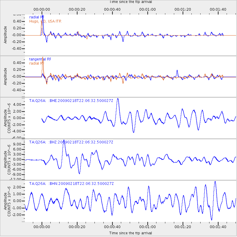
Signal To Noise
| Channel | StoN | STA | LTA |
| TA:Q26A: :BHZ:20090218T22:06:32.500027Z | 4.5532374 | 1.2676328E-6 | 2.7840252E-7 |
| TA:Q26A: :BHN:20090218T22:06:32.500027Z | 1.6275154 | 8.162407E-7 | 5.015256E-7 |
| TA:Q26A: :BHE:20090218T22:06:32.500027Z | 1.428431 | 6.700091E-7 | 4.6905248E-7 |
| Arrivals |
| Ps | 5.0 SECOND |
| PpPs | 20 SECOND |
| PsPs/PpSs | 25 SECOND |


