You are here: Home > Network List > TS - TERRAscope (Southern California Seismic Network) Stations List
> Station CALB Calabasas, California, USA > Earthquake Result Viewer
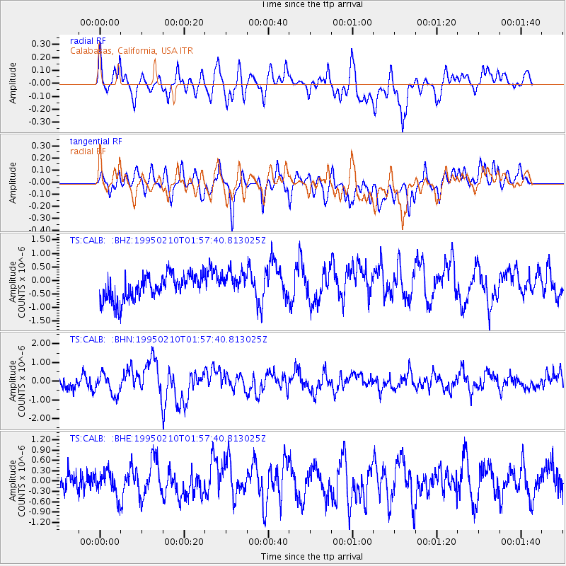
CALB Calabasas, California, USA - Earthquake Result Viewer
*The percent match for this event was below the threshold and hence no stack was calculated.
| Earthquake location: |
Off E. Coast Of N. Island, N.Z. |
| Earthquake latitude/longitude: |
-38.0/178.5 |
| Earthquake time(UTC): |
1995/02/10 (041) 01:45:04 GMT |
| Earthquake Depth: |
33 km |
| Earthquake Magnitude: |
5.8 MB, 6.4 MS, 6.5 UNKNOWN, 6.3 ML |
| Earthquake Catalog/Contributor: |
WHDF/NEIC |
|
| Network: |
TS TERRAscope (Southern California Seismic Network) |
| Station: |
CALB Calabasas, California, USA |
| Lat/Lon: |
34.14 N/118.63 W |
| Elevation: |
0.0 m |
|
| Distance: |
92.5 deg |
| Az: |
47.65 deg |
| Baz: |
224.77 deg |
| Ray Param: |
$rayparam |
*The percent match for this event was below the threshold and hence was not used in the summary stack. |
|
| Radial Match: |
62.332615 % |
| Radial Bump: |
400 |
| Transverse Match: |
61.01497 % |
| Transverse Bump: |
400 |
| SOD ConfigId: |
4480 |
| Insert Time: |
2010-02-26 14:03:27.512 +0000 |
| GWidth: |
2.5 |
| Max Bumps: |
400 |
| Tol: |
0.001 |
|
Signal To Noise
| Channel | StoN | STA | LTA |
| TS:CALB: :BHN:19950210T01:57:40.813025Z | 1.2776523 | 5.6250843E-7 | 4.4026723E-7 |
| TS:CALB: :BHE:19950210T01:57:40.813025Z | 0.9615303 | 3.6894915E-7 | 3.8371036E-7 |
| TS:CALB: :BHZ:19950210T01:57:40.813025Z | 0.96726954 | 4.4228142E-7 | 4.5724732E-7 |
| Arrivals |
| Ps | |
| PpPs | |
| PsPs/PpSs | |


