You are here: Home > Network List > TA - USArray Transportable Network (new EarthScope stations) Stations List
> Station Q26A Hugo, CO, USA > Earthquake Result Viewer
Q26A Hugo, CO, USA - Earthquake Result Viewer
| Earthquake location: |
Southern Peru |
| Earthquake latitude/longitude: |
-15.0/-70.4 |
| Earthquake time(UTC): |
2009/07/12 (193) 06:12:47 GMT |
| Earthquake Depth: |
199 km |
| Earthquake Magnitude: |
5.7 MB, 6.1 MW, 6.1 MW |
| Earthquake Catalog/Contributor: |
WHDF/NEIC |
|
| Network: |
TA USArray Transportable Network (new EarthScope stations) |
| Station: |
Q26A Hugo, CO, USA |
| Lat/Lon: |
38.92 N/103.52 W |
| Elevation: |
1546 m |
|
| Distance: |
62.0 deg |
| Az: |
331.162 deg |
| Baz: |
143.315 deg |
| Ray Param: |
0.05992504 |
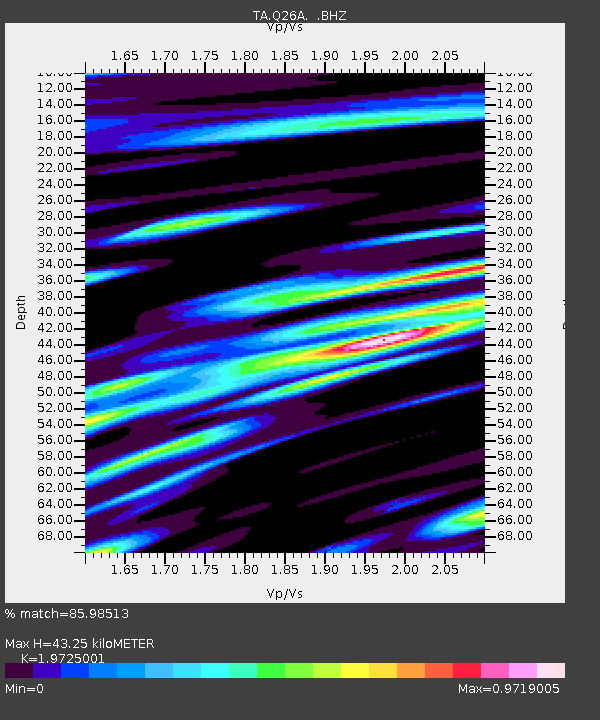
| Estimated Moho Depth: |
43.25 km |
| Estimated Crust Vp/Vs: |
1.97 |
| Assumed Crust Vp: |
6.242 km/s |
| Estimated Crust Vs: |
3.165 km/s |
| Estimated Crust Poisson's Ratio: |
0.33 |
|
| Radial Match: |
85.98513 % |
| Radial Bump: |
400 |
| Transverse Match: |
78.8582 % |
| Transverse Bump: |
400 |
| SOD ConfigId: |
2648 |
| Insert Time: |
2010-03-06 19:14:10.998 +0000 |
| GWidth: |
2.5 |
| Max Bumps: |
400 |
| Tol: |
0.001 |
|

Signal To Noise
| Channel | StoN | STA | LTA |
| TA:Q26A: :BHZ:20090712T06:22:15.22502Z | 19.448202 | 1.4115026E-6 | 7.2577535E-8 |
| TA:Q26A: :BHN:20090712T06:22:15.22502Z | 3.1131072 | 1.938745E-7 | 6.227685E-8 |
| TA:Q26A: :BHE:20090712T06:22:15.22502Z | 1.0769708 | 1.00770315E-7 | 9.356828E-8 |
| Arrivals |
| Ps | 7.0 SECOND |
| PpPs | 20 SECOND |
| PsPs/PpSs | 27 SECOND |


