You are here: Home > Network List > UU - University of Utah Regional Network Stations List
> Station BSUT Blindstream Canyon, Hanna, UT, USA > Earthquake Result Viewer
BSUT Blindstream Canyon, Hanna, UT, USA - Earthquake Result Viewer
| Earthquake location: |
Komandorskiye Ostrova Region |
| Earthquake latitude/longitude: |
54.3/168.6 |
| Earthquake time(UTC): |
2016/09/05 (249) 22:54:04 GMT |
| Earthquake Depth: |
10 km |
| Earthquake Magnitude: |
5.7 MB |
| Earthquake Catalog/Contributor: |
NEIC PDE/NEIC COMCAT |
|
| Network: |
UU University of Utah Regional Network |
| Station: |
BSUT Blindstream Canyon, Hanna, UT, USA |
| Lat/Lon: |
40.54 N/110.76 W |
| Elevation: |
3211 m |
|
| Distance: |
53.3 deg |
| Az: |
69.672 deg |
| Baz: |
313.916 deg |
| Ray Param: |
0.06618053 |
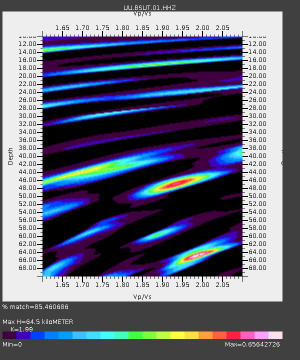
| Estimated Moho Depth: |
64.5 km |
| Estimated Crust Vp/Vs: |
1.99 |
| Assumed Crust Vp: |
6.155 km/s |
| Estimated Crust Vs: |
3.093 km/s |
| Estimated Crust Poisson's Ratio: |
0.33 |
|
| Radial Match: |
85.460686 % |
| Radial Bump: |
400 |
| Transverse Match: |
62.738625 % |
| Transverse Bump: |
400 |
| SOD ConfigId: |
1634031 |
| Insert Time: |
2016-09-19 23:01:30.534 +0000 |
| GWidth: |
2.5 |
| Max Bumps: |
400 |
| Tol: |
0.001 |
|

Signal To Noise
| Channel | StoN | STA | LTA |
| UU:BSUT:01:HHZ:20160905T23:02:52.567993Z | 2.3155193 | 8.134092E-9 | 3.5128582E-9 |
| UU:BSUT:01:HHN:20160905T23:02:52.567993Z | 1.2518376 | 6.6589694E-9 | 5.3193556E-9 |
| UU:BSUT:01:HHE:20160905T23:02:52.567993Z | 0.81317973 | 3.5710952E-9 | 4.3915205E-9 |
| Arrivals |
| Ps | 11 SECOND |
| PpPs | 30 SECOND |
| PsPs/PpSs | 41 SECOND |


