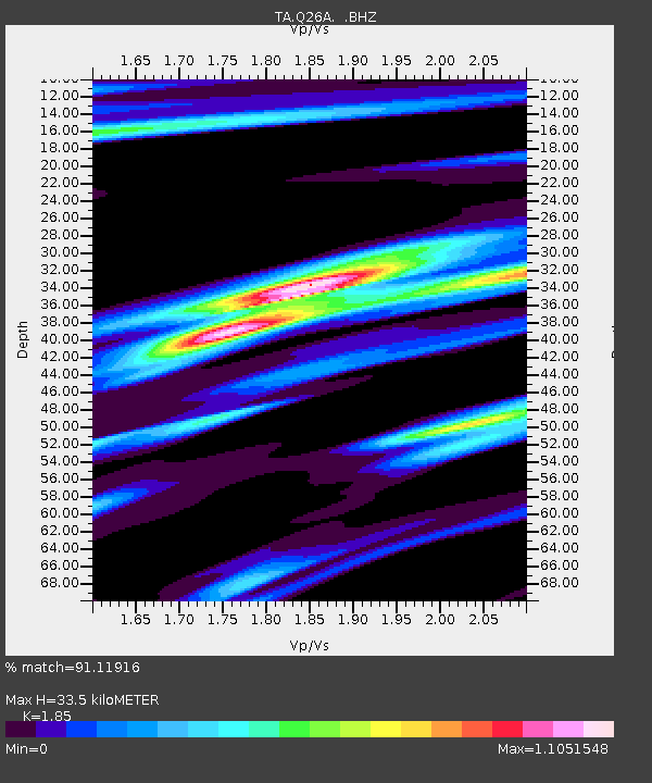
Q26A Hugo, CO, USA - Earthquake Result Viewer

Earthquake location: Kodiak Island Region, Alaska
Earthquake latitude/longitude: 56.5/-152.7
Earthquake time(UTC): 2009/03/30 (089) 07:13:07 GMT
Earthquake Depth: 21 km
Earthquake Magnitude: 5.9 MB, 5.9 MS, 5.9 MW, 5.9 MW
Earthquake Catalog/Contributor: WHDF/NEIC
Network: TA USArray Transportable Network (new EarthScope stations)
Station: Q26A Hugo, CO, USA
Lat/Lon: 38.92 N/103.52 W
Elevation: 1546 m
Distance: 36.6 deg
Az: 97.487 deg
Baz: 315.254 deg
Ray Param: 0.07658254
Estimated Moho Depth: 33.5 km
Estimated Crust Vp/Vs: 1.85
Assumed Crust Vp: 6.242 km/s
Estimated Crust Vs: 3.374 km/s
Estimated Crust Poisson's Ratio: 0.29
Radial Match: 91.11916 %
Radial Bump: 300
Transverse Match: 64.58226 %
Transverse Bump: 349
SOD ConfigId: 2658
Insert Time: 2010-03-06 19:14:12.578 +0000
GWidth: 2.5
Max Bumps: 400
Tol: 0.001

Signal To Noise

ChannelStoNSTALTA
TA:Q26A: :BHZ:20090330T07:19:40.875001Z11.35975551.6768431E-61.4761261E-7
TA:Q26A: :BHN:20090330T07:19:40.875001Z3.58756858.811438E-72.456103E-7
TA:Q26A: :BHE:20090330T07:19:40.875001Z2.86760238.7813333E-73.0622562E-7
Arrivals
Ps4.9 SECOND
PpPs14 SECOND
PsPs/PpSs19 SECOND