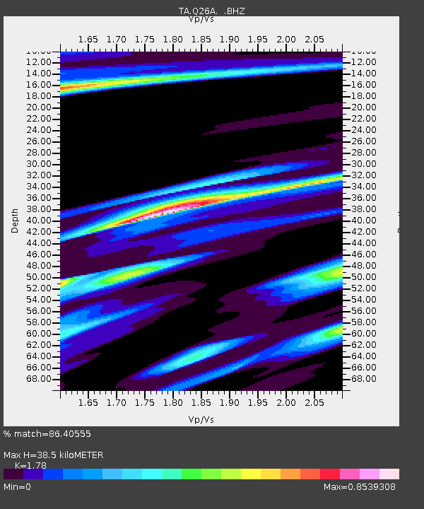
Q26A Hugo, CO, USA - Earthquake Result Viewer

Earthquake location: Kodiak Island Region, Alaska
Earthquake latitude/longitude: 56.4/-152.4
Earthquake time(UTC): 2009/05/16 (136) 18:22:25 GMT
Earthquake Depth: 9.7 km
Earthquake Magnitude: 5.9 MS, 5.4 MB, 5.9 MW, 5.8 MW
Earthquake Catalog/Contributor: WHDF/NEIC
Network: TA USArray Transportable Network (new EarthScope stations)
Station: Q26A Hugo, CO, USA
Lat/Lon: 38.92 N/103.52 W
Elevation: 1546 m
Distance: 36.4 deg
Az: 97.632 deg
Baz: 315.107 deg
Ray Param: 0.076713145
Estimated Moho Depth: 38.5 km
Estimated Crust Vp/Vs: 1.78
Assumed Crust Vp: 6.242 km/s
Estimated Crust Vs: 3.507 km/s
Estimated Crust Poisson's Ratio: 0.27
Radial Match: 86.40555 %
Radial Bump: 357
Transverse Match: 62.014343 %
Transverse Bump: 400
SOD ConfigId: 2760
Insert Time: 2010-03-06 19:14:20.072 +0000
GWidth: 2.5
Max Bumps: 400
Tol: 0.001

Signal To Noise

ChannelStoNSTALTA
TA:Q26A: :BHZ:20090516T18:28:58.873986Z1.59218571.2617744E-77.924794E-8
TA:Q26A: :BHN:20090516T18:28:58.873986Z1.21552.0967335E-71.7249967E-7
TA:Q26A: :BHE:20090516T18:28:58.873986Z1.57066352.0512329E-71.3059659E-7
Arrivals
Ps5.2 SECOND
PpPs16 SECOND
PsPs/PpSs21 SECOND