You are here: Home > Network List > UU - University of Utah Regional Network Stations List
> Station FORU South Mineral Mountains, UT, USA > Earthquake Result Viewer
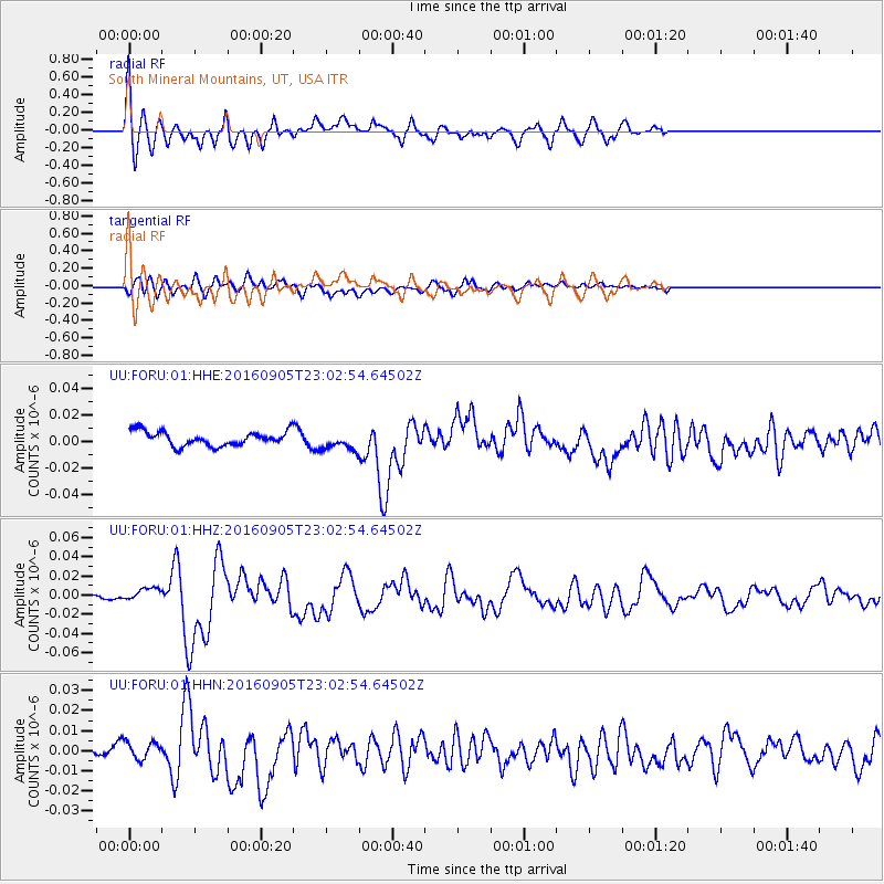
FORU South Mineral Mountains, UT, USA - Earthquake Result Viewer
*The percent match for this event was below the threshold and hence no stack was calculated.
| Earthquake location: |
Komandorskiye Ostrova Region |
| Earthquake latitude/longitude: |
54.3/168.6 |
| Earthquake time(UTC): |
2016/09/05 (249) 22:54:04 GMT |
| Earthquake Depth: |
10 km |
| Earthquake Magnitude: |
5.7 MB |
| Earthquake Catalog/Contributor: |
NEIC PDE/NEIC COMCAT |
|
| Network: |
UU University of Utah Regional Network |
| Station: |
FORU South Mineral Mountains, UT, USA |
| Lat/Lon: |
38.46 N/112.86 W |
| Elevation: |
1840 m |
|
| Distance: |
53.6 deg |
| Az: |
72.933 deg |
| Baz: |
314.528 deg |
| Ray Param: |
$rayparam |
*The percent match for this event was below the threshold and hence was not used in the summary stack. |
|
| Radial Match: |
72.13454 % |
| Radial Bump: |
400 |
| Transverse Match: |
57.068764 % |
| Transverse Bump: |
400 |
| SOD ConfigId: |
1634031 |
| Insert Time: |
2016-09-19 23:01:37.150 +0000 |
| GWidth: |
2.5 |
| Max Bumps: |
400 |
| Tol: |
0.001 |
|
Signal To Noise
| Channel | StoN | STA | LTA |
| UU:FORU:01:HHZ:20160905T23:02:54.64502Z | 2.727545 | 6.548197E-9 | 2.400766E-9 |
| UU:FORU:01:HHN:20160905T23:02:54.64502Z | 2.6778743 | 4.5153334E-9 | 1.6861633E-9 |
| UU:FORU:01:HHE:20160905T23:02:54.64502Z | 1.2881484 | 6.9317707E-9 | 5.3811897E-9 |
| Arrivals |
| Ps | |
| PpPs | |
| PsPs/PpSs | |


