You are here: Home > Network List > TS - TERRAscope (Southern California Seismic Network) Stations List
> Station CALB Calabasas, California, USA > Earthquake Result Viewer
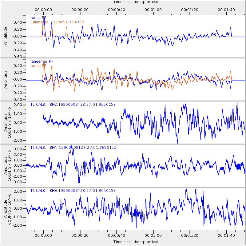
CALB Calabasas, California, USA - Earthquake Result Viewer
*The percent match for this event was below the threshold and hence no stack was calculated.
| Earthquake location: |
Andreanof Islands, Aleutian Is. |
| Earthquake latitude/longitude: |
51.5/-178.1 |
| Earthquake time(UTC): |
1996/06/08 (160) 23:19:15 GMT |
| Earthquake Depth: |
33 km |
| Earthquake Magnitude: |
5.9 MB, 6.3 MS, 6.5 UNKNOWN, 6.1 MS |
| Earthquake Catalog/Contributor: |
WHDF/NEIC |
|
| Network: |
TS TERRAscope (Southern California Seismic Network) |
| Station: |
CALB Calabasas, California, USA |
| Lat/Lon: |
34.14 N/118.63 W |
| Elevation: |
0.0 m |
|
| Distance: |
45.6 deg |
| Az: |
88.336 deg |
| Baz: |
311.106 deg |
| Ray Param: |
$rayparam |
*The percent match for this event was below the threshold and hence was not used in the summary stack. |
|
| Radial Match: |
51.64332 % |
| Radial Bump: |
400 |
| Transverse Match: |
61.654675 % |
| Transverse Bump: |
400 |
| SOD ConfigId: |
4480 |
| Insert Time: |
2010-02-26 14:03:28.454 +0000 |
| GWidth: |
2.5 |
| Max Bumps: |
400 |
| Tol: |
0.001 |
|
Signal To Noise
| Channel | StoN | STA | LTA |
| TS:CALB: :BHN:19960608T23:27:01.865015Z | 4.921142 | 7.6845066E-7 | 1.5615291E-7 |
| TS:CALB: :BHE:19960608T23:27:01.865015Z | 1.4807084 | 3.0902288E-7 | 2.0869936E-7 |
| TS:CALB: :BHZ:19960608T23:27:01.865015Z | 1.1844809 | 3.314712E-7 | 2.7984512E-7 |
| Arrivals |
| Ps | |
| PpPs | |
| PsPs/PpSs | |


