You are here: Home > Network List > UU - University of Utah Regional Network Stations List
> Station KNB Kanab, UT, USA > Earthquake Result Viewer
KNB Kanab, UT, USA - Earthquake Result Viewer
| Earthquake location: |
Komandorskiye Ostrova Region |
| Earthquake latitude/longitude: |
54.3/168.6 |
| Earthquake time(UTC): |
2016/09/05 (249) 22:54:04 GMT |
| Earthquake Depth: |
10 km |
| Earthquake Magnitude: |
5.7 MB |
| Earthquake Catalog/Contributor: |
NEIC PDE/NEIC COMCAT |
|
| Network: |
UU University of Utah Regional Network |
| Station: |
KNB Kanab, UT, USA |
| Lat/Lon: |
37.02 N/112.82 W |
| Elevation: |
1715 m |
|
| Distance: |
54.6 deg |
| Az: |
74.165 deg |
| Baz: |
315.273 deg |
| Ray Param: |
0.06532257 |
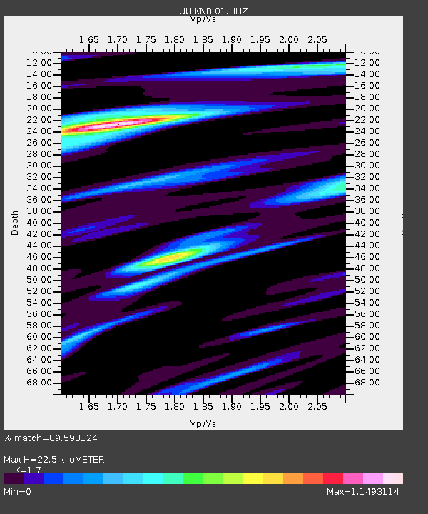
| Estimated Moho Depth: |
22.5 km |
| Estimated Crust Vp/Vs: |
1.70 |
| Assumed Crust Vp: |
6.194 km/s |
| Estimated Crust Vs: |
3.644 km/s |
| Estimated Crust Poisson's Ratio: |
0.24 |
|
| Radial Match: |
89.593124 % |
| Radial Bump: |
394 |
| Transverse Match: |
73.75634 % |
| Transverse Bump: |
368 |
| SOD ConfigId: |
1634031 |
| Insert Time: |
2016-09-19 23:01:42.337 +0000 |
| GWidth: |
2.5 |
| Max Bumps: |
400 |
| Tol: |
0.001 |
|

Signal To Noise
| Channel | StoN | STA | LTA |
| UU:KNB:01:HHZ:20160905T23:03:02.205017Z | 2.8583426 | 8.368622E-9 | 2.9277885E-9 |
| UU:KNB:01:HHN:20160905T23:03:02.205017Z | 1.322323 | 4.319025E-9 | 3.2662408E-9 |
| UU:KNB:01:HHE:20160905T23:03:02.205017Z | 1.3592728 | 4.47535E-9 | 3.2924588E-9 |
| Arrivals |
| Ps | 2.7 SECOND |
| PpPs | 9.3 SECOND |
| PsPs/PpSs | 12 SECOND |


