You are here: Home > Network List > TA - USArray Transportable Network (new EarthScope stations) Stations List
> Station B18K Kokolik River, AK, USA > Earthquake Result Viewer
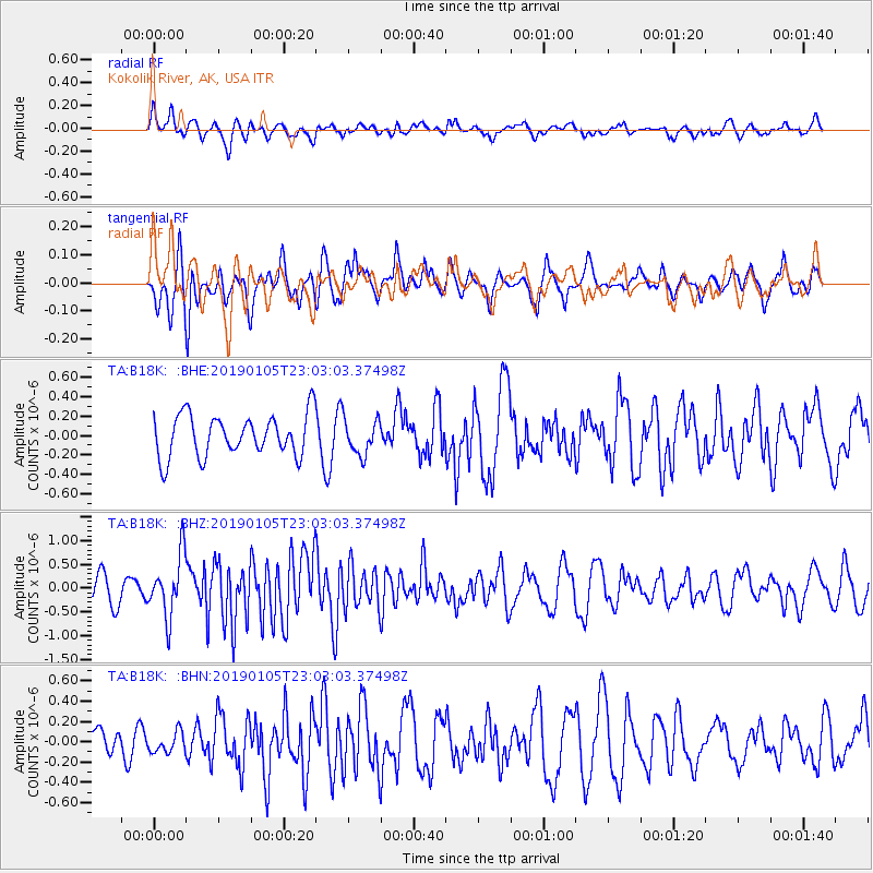
B18K Kokolik River, AK, USA - Earthquake Result Viewer
*The percent match for this event was below the threshold and hence no stack was calculated.
| Earthquake location: |
Volcano Islands, Japan Region |
| Earthquake latitude/longitude: |
25.8/144.6 |
| Earthquake time(UTC): |
2019/01/05 (005) 22:54:13 GMT |
| Earthquake Depth: |
8.3 km |
| Earthquake Magnitude: |
5.8 Mww |
| Earthquake Catalog/Contributor: |
NEIC PDE/us |
|
| Network: |
TA USArray Transportable Network (new EarthScope stations) |
| Station: |
B18K Kokolik River, AK, USA |
| Lat/Lon: |
69.36 N/161.80 W |
| Elevation: |
222 m |
|
| Distance: |
53.5 deg |
| Az: |
20.794 deg |
| Baz: |
244.48 deg |
| Ray Param: |
$rayparam |
*The percent match for this event was below the threshold and hence was not used in the summary stack. |
|
| Radial Match: |
55.17338 % |
| Radial Bump: |
400 |
| Transverse Match: |
63.977825 % |
| Transverse Bump: |
400 |
| SOD ConfigId: |
13570011 |
| Insert Time: |
2019-05-02 06:28:34.326 +0000 |
| GWidth: |
2.5 |
| Max Bumps: |
400 |
| Tol: |
0.001 |
|
Signal To Noise
| Channel | StoN | STA | LTA |
| TA:B18K: :BHZ:20190105T23:03:03.37498Z | 1.8066248 | 6.4674697E-7 | 3.5798632E-7 |
| TA:B18K: :BHN:20190105T23:03:03.37498Z | 0.62094784 | 1.0174078E-7 | 1.6384755E-7 |
| TA:B18K: :BHE:20190105T23:03:03.37498Z | 0.82314104 | 1.7744104E-7 | 2.1556576E-7 |
| Arrivals |
| Ps | |
| PpPs | |
| PsPs/PpSs | |


