You are here: Home > Network List > UU - University of Utah Regional Network Stations List
> Station WPUT Wasatch Plateau, UT,USA > Earthquake Result Viewer
WPUT Wasatch Plateau, UT,USA - Earthquake Result Viewer
| Earthquake location: |
Komandorskiye Ostrova Region |
| Earthquake latitude/longitude: |
54.3/168.6 |
| Earthquake time(UTC): |
2016/09/05 (249) 22:54:04 GMT |
| Earthquake Depth: |
10 km |
| Earthquake Magnitude: |
5.7 MB |
| Earthquake Catalog/Contributor: |
NEIC PDE/NEIC COMCAT |
|
| Network: |
UU University of Utah Regional Network |
| Station: |
WPUT Wasatch Plateau, UT,USA |
| Lat/Lon: |
39.00 N/111.36 W |
| Elevation: |
2618 m |
|
| Distance: |
54.1 deg |
| Az: |
71.437 deg |
| Baz: |
314.581 deg |
| Ray Param: |
0.065683626 |
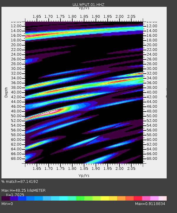
| Estimated Moho Depth: |
48.25 km |
| Estimated Crust Vp/Vs: |
1.70 |
| Assumed Crust Vp: |
6.207 km/s |
| Estimated Crust Vs: |
3.646 km/s |
| Estimated Crust Poisson's Ratio: |
0.24 |
|
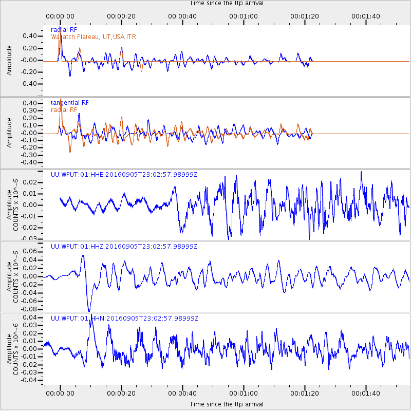
| Radial Match: |
87.14192 % |
| Radial Bump: |
400 |
| Transverse Match: |
67.32563 % |
| Transverse Bump: |
400 |
| SOD ConfigId: |
1634031 |
| Insert Time: |
2016-09-19 23:02:06.802 +0000 |
| GWidth: |
2.5 |
| Max Bumps: |
400 |
| Tol: |
0.001 |
|
Signal To Noise
| Channel | StoN | STA | LTA |
| UU:WPUT:01:HHZ:20160905T23:02:57.98999Z | 2.916795 | 8.450758E-9 | 2.8972753E-9 |
| UU:WPUT:01:HHN:20160905T23:02:57.98999Z | 0.8783243 | 3.9391823E-9 | 4.484884E-9 |
| UU:WPUT:01:HHE:20160905T23:02:57.98999Z | 0.97432876 | 3.5826546E-9 | 3.677049E-9 |
| Arrivals |
| Ps | 5.8 SECOND |
| PpPs | 20 SECOND |
| PsPs/PpSs | 26 SECOND |


