You are here: Home > Network List > TA - USArray Transportable Network (new EarthScope stations) Stations List
> Station Q26A Hugo, CO, USA > Earthquake Result Viewer
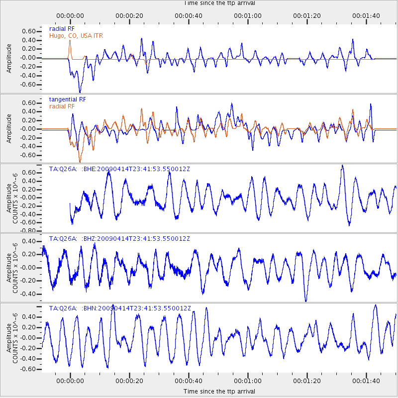
Q26A Hugo, CO, USA - Earthquake Result Viewer
*The percent match for this event was below the threshold and hence no stack was calculated.
| Earthquake location: |
Fiji Islands Region |
| Earthquake latitude/longitude: |
-16.3/-177.7 |
| Earthquake time(UTC): |
2009/04/14 (104) 23:29:33 GMT |
| Earthquake Depth: |
10 km |
| Earthquake Magnitude: |
5.5 MS, 5.4 MB, 5.9 MW, 5.9 MW |
| Earthquake Catalog/Contributor: |
WHDF/NEIC |
|
| Network: |
TA USArray Transportable Network (new EarthScope stations) |
| Station: |
Q26A Hugo, CO, USA |
| Lat/Lon: |
38.92 N/103.52 W |
| Elevation: |
1546 m |
|
| Distance: |
88.3 deg |
| Az: |
48.672 deg |
| Baz: |
247.584 deg |
| Ray Param: |
$rayparam |
*The percent match for this event was below the threshold and hence was not used in the summary stack. |
|
| Radial Match: |
54.542774 % |
| Radial Bump: |
400 |
| Transverse Match: |
40.386757 % |
| Transverse Bump: |
400 |
| SOD ConfigId: |
2658 |
| Insert Time: |
2010-03-06 19:15:06.118 +0000 |
| GWidth: |
2.5 |
| Max Bumps: |
400 |
| Tol: |
0.001 |
|
Signal To Noise
| Channel | StoN | STA | LTA |
| TA:Q26A: :BHZ:20090414T23:41:53.550012Z | 1.05817 | 1.5721422E-7 | 1.4857181E-7 |
| TA:Q26A: :BHN:20090414T23:41:53.550012Z | 1.3351554 | 3.9535252E-7 | 2.9610976E-7 |
| TA:Q26A: :BHE:20090414T23:41:53.550012Z | 1.0928465 | 3.0933805E-7 | 2.8305718E-7 |
| Arrivals |
| Ps | |
| PpPs | |
| PsPs/PpSs | |


