You are here: Home > Network List > TA - USArray Transportable Network (new EarthScope stations) Stations List
> Station N27A Anderson Farm, Haxtun, CO, USA > Earthquake Result Viewer
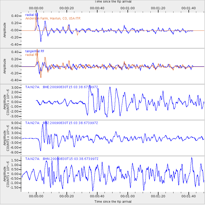
N27A Anderson Farm, Haxtun, CO, USA - Earthquake Result Viewer
| Earthquake location: |
Samoa Islands Region |
| Earthquake latitude/longitude: |
-15.2/-172.6 |
| Earthquake time(UTC): |
2009/08/30 (242) 14:51:32 GMT |
| Earthquake Depth: |
11 km |
| Earthquake Magnitude: |
6.4 MB, 6.3 MS, 6.6 MW, 6.6 MW |
| Earthquake Catalog/Contributor: |
WHDF/NEIC |
|
| Network: |
TA USArray Transportable Network (new EarthScope stations) |
| Station: |
N27A Anderson Farm, Haxtun, CO, USA |
| Lat/Lon: |
40.81 N/102.54 W |
| Elevation: |
1228 m |
|
| Distance: |
85.4 deg |
| Az: |
45.707 deg |
| Baz: |
245.544 deg |
| Ray Param: |
0.044796 |
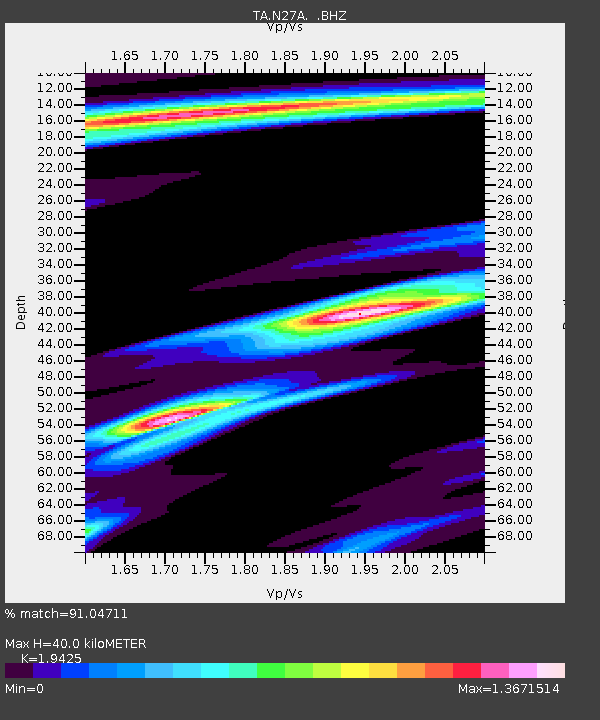
| Estimated Moho Depth: |
40.0 km |
| Estimated Crust Vp/Vs: |
1.94 |
| Assumed Crust Vp: |
6.483 km/s |
| Estimated Crust Vs: |
3.337 km/s |
| Estimated Crust Poisson's Ratio: |
0.32 |
|
| Radial Match: |
91.04711 % |
| Radial Bump: |
360 |
| Transverse Match: |
82.277145 % |
| Transverse Bump: |
400 |
| SOD ConfigId: |
2622 |
| Insert Time: |
2010-03-06 19:15:17.224 +0000 |
| GWidth: |
2.5 |
| Max Bumps: |
400 |
| Tol: |
0.001 |
|
Signal To Noise
| Channel | StoN | STA | LTA |
| TA:N27A: :BHZ:20090830T15:03:38.673997Z | 24.772278 | 3.9716715E-6 | 1.6032726E-7 |
| TA:N27A: :BHN:20090830T15:03:38.673997Z | 2.1948304 | 4.3305073E-7 | 1.9730487E-7 |
| TA:N27A: :BHE:20090830T15:03:38.673997Z | 4.4583473 | 1.3068181E-6 | 2.9311715E-7 |
| Arrivals |
| Ps | 5.9 SECOND |
| PpPs | 18 SECOND |
| PsPs/PpSs | 24 SECOND |


