You are here: Home > Network List > TS - TERRAscope (Southern California Seismic Network) Stations List
> Station CALB Calabasas, California, USA > Earthquake Result Viewer
CALB Calabasas, California, USA - Earthquake Result Viewer
*The percent match for this event was below the threshold and hence no stack was calculated.
| Earthquake location: |
Kuril Islands |
| Earthquake latitude/longitude: |
45.9/151.6 |
| Earthquake time(UTC): |
1995/02/21 (052) 02:09:50 GMT |
| Earthquake Depth: |
33 km |
| Earthquake Magnitude: |
5.8 MB, 5.9 MS, 6.2 UNKNOWN, 6.1 MW |
| Earthquake Catalog/Contributor: |
WHDF/NEIC |
|
| Network: |
TS TERRAscope (Southern California Seismic Network) |
| Station: |
CALB Calabasas, California, USA |
| Lat/Lon: |
34.14 N/118.63 W |
| Elevation: |
0.0 m |
|
| Distance: |
66.3 deg |
| Az: |
64.93 deg |
| Baz: |
310.352 deg |
| Ray Param: |
$rayparam |
*The percent match for this event was below the threshold and hence was not used in the summary stack. |
|
| Radial Match: |
44.142796 % |
| Radial Bump: |
400 |
| Transverse Match: |
35.87414 % |
| Transverse Bump: |
400 |
| SOD ConfigId: |
4480 |
| Insert Time: |
2010-02-26 14:03:30.066 +0000 |
| GWidth: |
2.5 |
| Max Bumps: |
400 |
| Tol: |
0.001 |
|
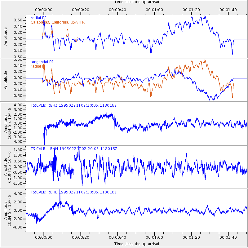
Signal To Noise
| Channel | StoN | STA | LTA |
| TS:CALB: :BHN:19950221T02:20:05.118018Z | 1.0713389 | 2.5596145E-7 | 2.3891735E-7 |
| TS:CALB: :BHE:19950221T02:20:05.118018Z | 1.210214 | 8.354712E-7 | 6.903499E-7 |
| TS:CALB: :BHZ:19950221T02:20:05.118018Z | 2.5744882 | 1.862857E-6 | 7.235834E-7 |
| Arrivals |
| Ps | |
| PpPs | |
| PsPs/PpSs | |


