You are here: Home > Network List > TA - USArray Transportable Network (new EarthScope stations) Stations List
> Station N27A Anderson Farm, Haxtun, CO, USA > Earthquake Result Viewer
N27A Anderson Farm, Haxtun, CO, USA - Earthquake Result Viewer
| Earthquake location: |
Hokkaido, Japan Region |
| Earthquake latitude/longitude: |
41.8/143.4 |
| Earthquake time(UTC): |
2009/06/05 (156) 03:30:33 GMT |
| Earthquake Depth: |
29 km |
| Earthquake Magnitude: |
6.0 MB, 6.3 MS, 6.4 MW, 6.4 MW |
| Earthquake Catalog/Contributor: |
WHDF/NEIC |
|
| Network: |
TA USArray Transportable Network (new EarthScope stations) |
| Station: |
N27A Anderson Farm, Haxtun, CO, USA |
| Lat/Lon: |
40.81 N/102.54 W |
| Elevation: |
1228 m |
|
| Distance: |
78.4 deg |
| Az: |
45.064 deg |
| Baz: |
315.813 deg |
| Ray Param: |
0.04964897 |
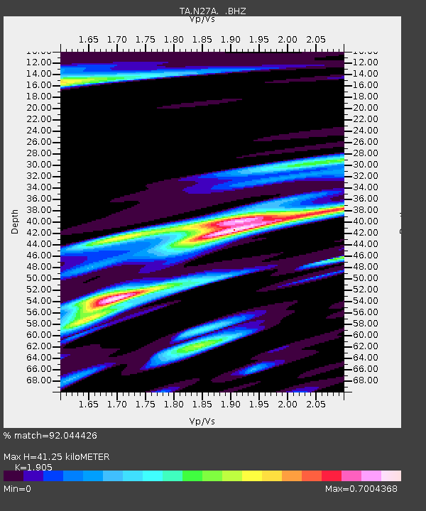
| Estimated Moho Depth: |
41.25 km |
| Estimated Crust Vp/Vs: |
1.90 |
| Assumed Crust Vp: |
6.483 km/s |
| Estimated Crust Vs: |
3.403 km/s |
| Estimated Crust Poisson's Ratio: |
0.31 |
|
| Radial Match: |
92.044426 % |
| Radial Bump: |
373 |
| Transverse Match: |
73.72516 % |
| Transverse Bump: |
400 |
| SOD ConfigId: |
2648 |
| Insert Time: |
2010-03-06 19:15:21.975 +0000 |
| GWidth: |
2.5 |
| Max Bumps: |
400 |
| Tol: |
0.001 |
|

Signal To Noise
| Channel | StoN | STA | LTA |
| TA:N27A: :BHZ:20090605T03:41:59.549014Z | 15.133257 | 1.2209372E-6 | 8.067907E-8 |
| TA:N27A: :BHN:20090605T03:41:59.549014Z | 2.9369693 | 3.5432575E-7 | 1.2064334E-7 |
| TA:N27A: :BHE:20090605T03:41:59.549014Z | 4.133992 | 3.2790882E-7 | 7.932014E-8 |
| Arrivals |
| Ps | 5.9 SECOND |
| PpPs | 18 SECOND |
| PsPs/PpSs | 24 SECOND |


