You are here: Home > Network List > CN - Canadian National Seismograph Network Stations List
> Station INK INUVIK, NT > Earthquake Result Viewer
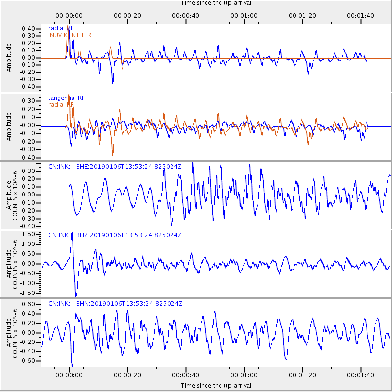
INK INUVIK, NT - Earthquake Result Viewer
*The percent match for this event was below the threshold and hence no stack was calculated.
| Earthquake location: |
Iran-Iraq Border Region |
| Earthquake latitude/longitude: |
34.1/45.7 |
| Earthquake time(UTC): |
2019/01/06 (006) 13:42:01 GMT |
| Earthquake Depth: |
25 km |
| Earthquake Magnitude: |
5.8 mb |
| Earthquake Catalog/Contributor: |
NEIC PDE/us |
|
| Network: |
CN Canadian National Seismograph Network |
| Station: |
INK INUVIK, NT |
| Lat/Lon: |
68.31 N/133.53 W |
| Elevation: |
44 m |
|
| Distance: |
77.9 deg |
| Az: |
359.695 deg |
| Baz: |
0.681 deg |
| Ray Param: |
$rayparam |
*The percent match for this event was below the threshold and hence was not used in the summary stack. |
|
| Radial Match: |
61.742397 % |
| Radial Bump: |
358 |
| Transverse Match: |
61.383682 % |
| Transverse Bump: |
400 |
| SOD ConfigId: |
13570011 |
| Insert Time: |
2019-05-02 06:33:58.793 +0000 |
| GWidth: |
2.5 |
| Max Bumps: |
400 |
| Tol: |
0.001 |
|
Signal To Noise
| Channel | StoN | STA | LTA |
| CN:INK: :BHZ:20190106T13:53:24.825024Z | 4.7665706 | 8.234408E-7 | 1.727533E-7 |
| CN:INK: :BHN:20190106T13:53:24.825024Z | 1.2813661 | 3.333135E-7 | 2.6012353E-7 |
| CN:INK: :BHE:20190106T13:53:24.825024Z | 1.5078057 | 1.8242349E-7 | 1.2098607E-7 |
| Arrivals |
| Ps | |
| PpPs | |
| PsPs/PpSs | |


