You are here: Home > Network List > TA - USArray Transportable Network (new EarthScope stations) Stations List
> Station N27A Anderson Farm, Haxtun, CO, USA > Earthquake Result Viewer
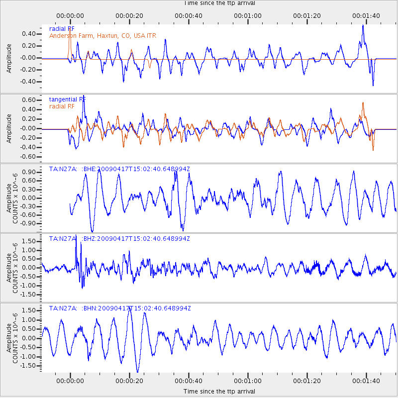
N27A Anderson Farm, Haxtun, CO, USA - Earthquake Result Viewer
*The percent match for this event was below the threshold and hence no stack was calculated.
| Earthquake location: |
Kuril Islands |
| Earthquake latitude/longitude: |
46.2/151.7 |
| Earthquake time(UTC): |
2009/04/17 (107) 14:51:58 GMT |
| Earthquake Depth: |
49 km |
| Earthquake Magnitude: |
5.5 MB, 5.0 MS, 5.7 MW, 5.6 MW |
| Earthquake Catalog/Contributor: |
WHDF/NEIC |
|
| Network: |
TA USArray Transportable Network (new EarthScope stations) |
| Station: |
N27A Anderson Farm, Haxtun, CO, USA |
| Lat/Lon: |
40.81 N/102.54 W |
| Elevation: |
1228 m |
|
| Distance: |
71.0 deg |
| Az: |
50.573 deg |
| Baz: |
314.994 deg |
| Ray Param: |
$rayparam |
*The percent match for this event was below the threshold and hence was not used in the summary stack. |
|
| Radial Match: |
39.559402 % |
| Radial Bump: |
336 |
| Transverse Match: |
55.68907 % |
| Transverse Bump: |
377 |
| SOD ConfigId: |
2658 |
| Insert Time: |
2010-03-06 19:16:16.064 +0000 |
| GWidth: |
2.5 |
| Max Bumps: |
400 |
| Tol: |
0.001 |
|
Signal To Noise
| Channel | StoN | STA | LTA |
| TA:N27A: :BHZ:20090417T15:02:40.648994Z | 2.6176155 | 5.91992E-7 | 2.2615697E-7 |
| TA:N27A: :BHN:20090417T15:02:40.648994Z | 1.6024507 | 5.1731774E-7 | 3.2282912E-7 |
| TA:N27A: :BHE:20090417T15:02:40.648994Z | 0.7382709 | 3.4669176E-7 | 4.6959968E-7 |
| Arrivals |
| Ps | |
| PpPs | |
| PsPs/PpSs | |


