You are here: Home > Network List > TA - USArray Transportable Network (new EarthScope stations) Stations List
> Station C16K Lisburne Hills, AK, USA > Earthquake Result Viewer
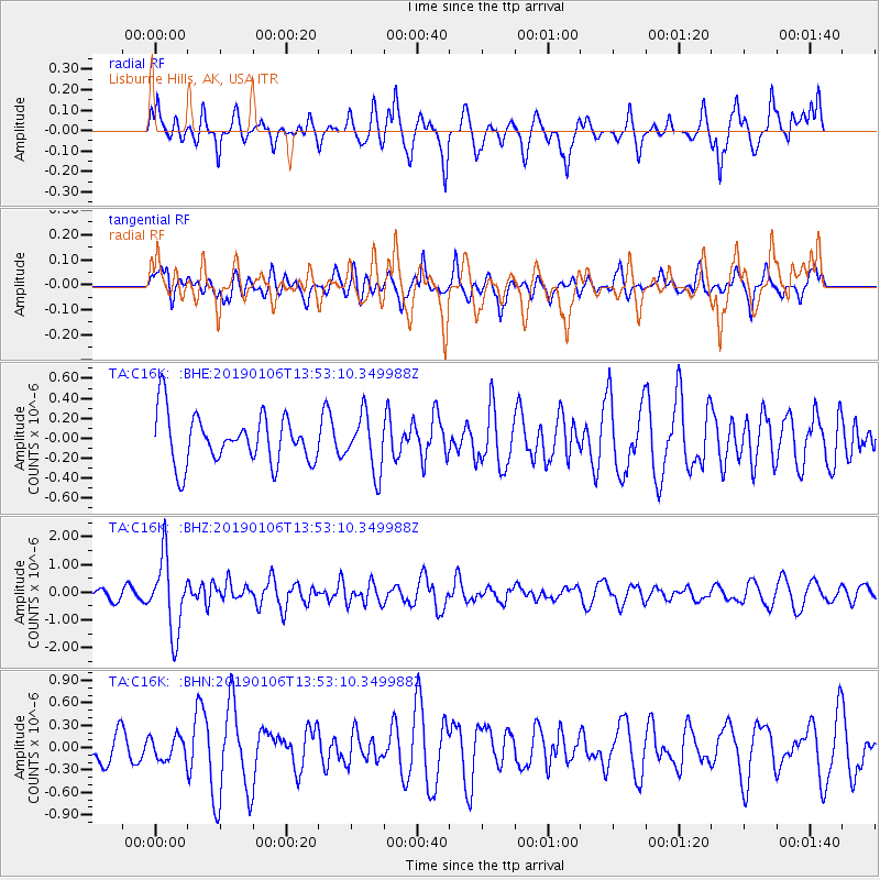
C16K Lisburne Hills, AK, USA - Earthquake Result Viewer
*The percent match for this event was below the threshold and hence no stack was calculated.
| Earthquake location: |
Iran-Iraq Border Region |
| Earthquake latitude/longitude: |
34.1/45.7 |
| Earthquake time(UTC): |
2019/01/06 (006) 13:42:01 GMT |
| Earthquake Depth: |
25 km |
| Earthquake Magnitude: |
5.8 mb |
| Earthquake Catalog/Contributor: |
NEIC PDE/us |
|
| Network: |
TA USArray Transportable Network (new EarthScope stations) |
| Station: |
C16K Lisburne Hills, AK, USA |
| Lat/Lon: |
68.27 N/165.34 W |
| Elevation: |
102 m |
|
| Distance: |
75.3 deg |
| Az: |
11.439 deg |
| Baz: |
333.777 deg |
| Ray Param: |
$rayparam |
*The percent match for this event was below the threshold and hence was not used in the summary stack. |
|
| Radial Match: |
64.92468 % |
| Radial Bump: |
400 |
| Transverse Match: |
57.739666 % |
| Transverse Bump: |
400 |
| SOD ConfigId: |
13570011 |
| Insert Time: |
2019-05-02 06:37:13.589 +0000 |
| GWidth: |
2.5 |
| Max Bumps: |
400 |
| Tol: |
0.001 |
|
Signal To Noise
| Channel | StoN | STA | LTA |
| TA:C16K: :BHZ:20190106T13:53:10.349988Z | 4.7909036 | 1.3294508E-6 | 2.774948E-7 |
| TA:C16K: :BHN:20190106T13:53:10.349988Z | 0.3682517 | 1.5353756E-7 | 4.1693642E-7 |
| TA:C16K: :BHE:20190106T13:53:10.349988Z | 1.1449082 | 2.8125578E-7 | 2.4565793E-7 |
| Arrivals |
| Ps | |
| PpPs | |
| PsPs/PpSs | |


