You are here: Home > Network List > TA - USArray Transportable Network (new EarthScope stations) Stations List
> Station F21K Alatna River, AK, USA > Earthquake Result Viewer
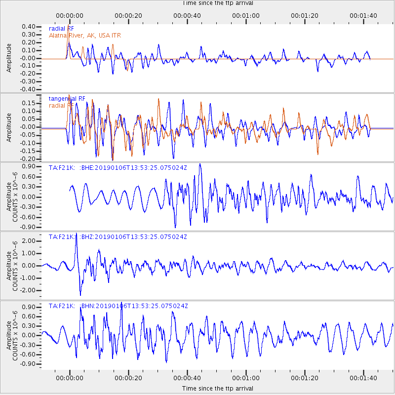
F21K Alatna River, AK, USA - Earthquake Result Viewer
*The percent match for this event was below the threshold and hence no stack was calculated.
| Earthquake location: |
Iran-Iraq Border Region |
| Earthquake latitude/longitude: |
34.1/45.7 |
| Earthquake time(UTC): |
2019/01/06 (006) 13:42:01 GMT |
| Earthquake Depth: |
25 km |
| Earthquake Magnitude: |
5.8 mb |
| Earthquake Catalog/Contributor: |
NEIC PDE/us |
|
| Network: |
TA USArray Transportable Network (new EarthScope stations) |
| Station: |
F21K Alatna River, AK, USA |
| Lat/Lon: |
67.22 N/153.48 W |
| Elevation: |
597 m |
|
| Distance: |
77.9 deg |
| Az: |
7.508 deg |
| Baz: |
343.839 deg |
| Ray Param: |
$rayparam |
*The percent match for this event was below the threshold and hence was not used in the summary stack. |
|
| Radial Match: |
68.77787 % |
| Radial Bump: |
400 |
| Transverse Match: |
56.727345 % |
| Transverse Bump: |
400 |
| SOD ConfigId: |
13570011 |
| Insert Time: |
2019-05-02 06:37:54.358 +0000 |
| GWidth: |
2.5 |
| Max Bumps: |
400 |
| Tol: |
0.001 |
|
Signal To Noise
| Channel | StoN | STA | LTA |
| TA:F21K: :BHZ:20190106T13:53:25.075024Z | 5.373728 | 1.1289218E-6 | 2.100817E-7 |
| TA:F21K: :BHN:20190106T13:53:25.075024Z | 3.5859573 | 3.855457E-7 | 1.0751542E-7 |
| TA:F21K: :BHE:20190106T13:53:25.075024Z | 1.2209666 | 2.6086786E-7 | 2.1365685E-7 |
| Arrivals |
| Ps | |
| PpPs | |
| PsPs/PpSs | |


