You are here: Home > Network List > TA - USArray Transportable Network (new EarthScope stations) Stations List
> Station H16K Elim, AK, USA > Earthquake Result Viewer
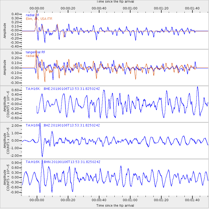
H16K Elim, AK, USA - Earthquake Result Viewer
*The percent match for this event was below the threshold and hence no stack was calculated.
| Earthquake location: |
Iran-Iraq Border Region |
| Earthquake latitude/longitude: |
34.1/45.7 |
| Earthquake time(UTC): |
2019/01/06 (006) 13:42:01 GMT |
| Earthquake Depth: |
25 km |
| Earthquake Magnitude: |
5.8 mb |
| Earthquake Catalog/Contributor: |
NEIC PDE/us |
|
| Network: |
TA USArray Transportable Network (new EarthScope stations) |
| Station: |
H16K Elim, AK, USA |
| Lat/Lon: |
64.64 N/162.24 W |
| Elevation: |
216 m |
|
| Distance: |
79.1 deg |
| Az: |
11.846 deg |
| Baz: |
336.711 deg |
| Ray Param: |
$rayparam |
*The percent match for this event was below the threshold and hence was not used in the summary stack. |
|
| Radial Match: |
68.127235 % |
| Radial Bump: |
370 |
| Transverse Match: |
56.523804 % |
| Transverse Bump: |
400 |
| SOD ConfigId: |
13570011 |
| Insert Time: |
2019-05-02 06:38:08.970 +0000 |
| GWidth: |
2.5 |
| Max Bumps: |
400 |
| Tol: |
0.001 |
|
Signal To Noise
| Channel | StoN | STA | LTA |
| TA:H16K: :BHZ:20190106T13:53:31.825024Z | 6.8932714 | 1.0995883E-6 | 1.5951618E-7 |
| TA:H16K: :BHN:20190106T13:53:31.825024Z | 2.6840029 | 5.1452446E-7 | 1.9170042E-7 |
| TA:H16K: :BHE:20190106T13:53:31.825024Z | 1.0359875 | 2.5861334E-7 | 2.4962978E-7 |
| Arrivals |
| Ps | |
| PpPs | |
| PsPs/PpSs | |


