You are here: Home > Network List > TA - USArray Transportable Network (new EarthScope stations) Stations List
> Station I30M Mount Dempster, Yukon, CAN > Earthquake Result Viewer
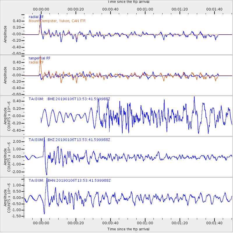
I30M Mount Dempster, Yukon, CAN - Earthquake Result Viewer
*The percent match for this event was below the threshold and hence no stack was calculated.
| Earthquake location: |
Iran-Iraq Border Region |
| Earthquake latitude/longitude: |
34.1/45.7 |
| Earthquake time(UTC): |
2019/01/06 (006) 13:42:01 GMT |
| Earthquake Depth: |
25 km |
| Earthquake Magnitude: |
5.8 mb |
| Earthquake Catalog/Contributor: |
NEIC PDE/us |
|
| Network: |
TA USArray Transportable Network (new EarthScope stations) |
| Station: |
I30M Mount Dempster, Yukon, CAN |
| Lat/Lon: |
65.22 N/136.38 W |
| Elevation: |
1399 m |
|
| Distance: |
81.0 deg |
| Az: |
0.874 deg |
| Baz: |
358.28 deg |
| Ray Param: |
$rayparam |
*The percent match for this event was below the threshold and hence was not used in the summary stack. |
|
| Radial Match: |
74.454414 % |
| Radial Bump: |
400 |
| Transverse Match: |
69.27612 % |
| Transverse Bump: |
400 |
| SOD ConfigId: |
13570011 |
| Insert Time: |
2019-05-02 06:38:23.275 +0000 |
| GWidth: |
2.5 |
| Max Bumps: |
400 |
| Tol: |
0.001 |
|
Signal To Noise
| Channel | StoN | STA | LTA |
| TA:I30M: :BHZ:20190106T13:53:41.599988Z | 8.568824 | 1.098171E-6 | 1.2815889E-7 |
| TA:I30M: :BHN:20190106T13:53:41.599988Z | 3.6344986 | 7.1050204E-7 | 1.9548831E-7 |
| TA:I30M: :BHE:20190106T13:53:41.599988Z | 2.1369662 | 2.2385878E-7 | 1.04755415E-7 |
| Arrivals |
| Ps | |
| PpPs | |
| PsPs/PpSs | |


