You are here: Home > Network List > TA - USArray Transportable Network (new EarthScope stations) Stations List
> Station M27A Reverse DX Ranch, Oshkosh, NE, USA > Earthquake Result Viewer
M27A Reverse DX Ranch, Oshkosh, NE, USA - Earthquake Result Viewer

| Earthquake location: |
Southeast Of Honshu, Japan |
| Earthquake latitude/longitude: |
32.8/140.4 |
| Earthquake time(UTC): |
2009/08/12 (224) 22:48:51 GMT |
| Earthquake Depth: |
53 km |
| Earthquake Magnitude: |
6.2 MB, 6.6 MW, 6.6 MW |
| Earthquake Catalog/Contributor: |
WHDF/NEIC |
|
| Network: |
TA USArray Transportable Network (new EarthScope stations) |
| Station: |
M27A Reverse DX Ranch, Oshkosh, NE, USA |
| Lat/Lon: |
41.53 N/102.39 W |
| Elevation: |
1147 m |
|
| Distance: |
86.2 deg |
| Az: |
42.006 deg |
| Baz: |
311.368 deg |
| Ray Param: |
0.044165853 |
| Estimated Moho Depth: |
45.5 km |
| Estimated Crust Vp/Vs: |
1.82 |
| Assumed Crust Vp: |
6.483 km/s |
| Estimated Crust Vs: |
3.572 km/s |
| Estimated Crust Poisson's Ratio: |
0.28 |
|
| Radial Match: |
91.4622 % |
| Radial Bump: |
243 |
| Transverse Match: |
50.931427 % |
| Transverse Bump: |
400 |
| SOD ConfigId: |
2622 |
| Insert Time: |
2010-03-06 19:16:58.110 +0000 |
| GWidth: |
2.5 |
| Max Bumps: |
400 |
| Tol: |
0.001 |
|
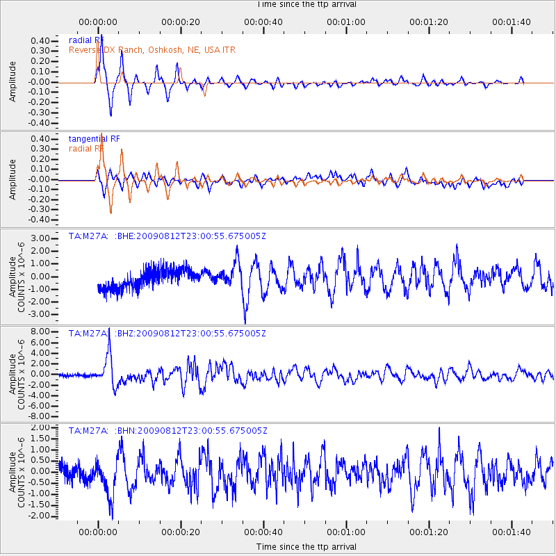
Signal To Noise
| Channel | StoN | STA | LTA |
| TA:M27A: :BHZ:20090812T23:00:55.675005Z | 12.225377 | 2.9843873E-6 | 2.4411412E-7 |
| TA:M27A: :BHN:20090812T23:00:55.675005Z | 1.3687764 | 8.9760664E-7 | 6.55773E-7 |
| TA:M27A: :BHE:20090812T23:00:55.675005Z | 1.3360655 | 9.680782E-7 | 7.245739E-7 |
| Arrivals |
| Ps | 5.9 SECOND |
| PpPs | 19 SECOND |
| PsPs/PpSs | 25 SECOND |


