You are here: Home > Network List > TA - USArray Transportable Network (new EarthScope stations) Stations List
> Station M27A Reverse DX Ranch, Oshkosh, NE, USA > Earthquake Result Viewer
M27A Reverse DX Ranch, Oshkosh, NE, USA - Earthquake Result Viewer
| Earthquake location: |
Norwegian Sea |
| Earthquake latitude/longitude: |
72.2/0.9 |
| Earthquake time(UTC): |
2009/08/20 (232) 06:35:04 GMT |
| Earthquake Depth: |
6.0 km |
| Earthquake Magnitude: |
5.9 MB, 5.7 MS, 6.0 MW, 6.0 MW |
| Earthquake Catalog/Contributor: |
WHDF/NEIC |
|
| Network: |
TA USArray Transportable Network (new EarthScope stations) |
| Station: |
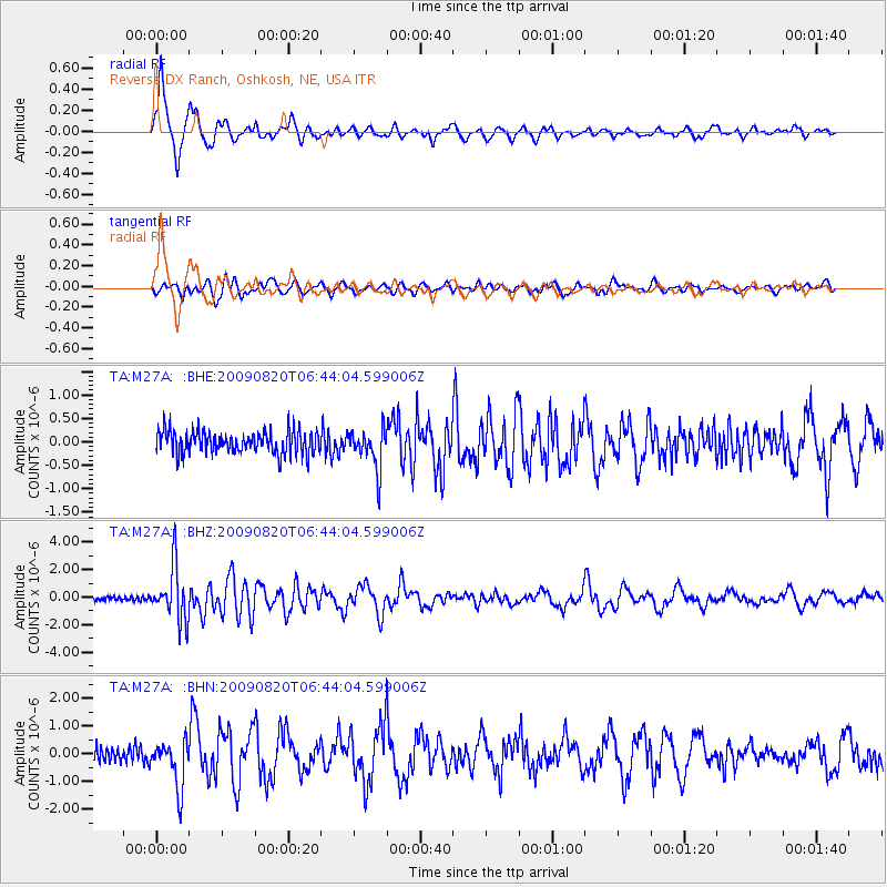
M27A Reverse DX Ranch, Oshkosh, NE, USA |
| Lat/Lon: |
41.53 N/102.39 W |
| Elevation: |
1147 m |
|
| Distance: |
54.9 deg |
| Az: |
296.726 deg |
| Baz: |
21.461 deg |
| Ray Param: |
0.0651711 |
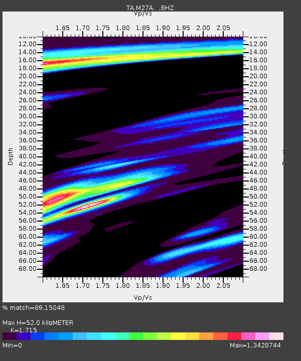
| Estimated Moho Depth: |
52.0 km |
| Estimated Crust Vp/Vs: |
1.72 |
| Assumed Crust Vp: |
6.483 km/s |
| Estimated Crust Vs: |
3.78 km/s |
| Estimated Crust Poisson's Ratio: |
0.24 |
|
| Radial Match: |
89.15048 % |
| Radial Bump: |
367 |
| Transverse Match: |
74.89714 % |
| Transverse Bump: |
400 |
| SOD ConfigId: |
2622 |
| Insert Time: |
2010-03-06 19:16:59.639 +0000 |
| GWidth: |
2.5 |
| Max Bumps: |
400 |
| Tol: |
0.001 |
|
Signal To Noise
| Channel | StoN | STA | LTA |
| TA:M27A: :BHZ:20090820T06:44:04.599006Z | 13.4656105 | 1.9468002E-6 | 1.4457571E-7 |
| TA:M27A: :BHN:20090820T06:44:04.599006Z | 2.525471 | 8.474504E-7 | 3.3556134E-7 |
| TA:M27A: :BHE:20090820T06:44:04.599006Z | 1.7895832 | 4.287859E-7 | 2.3960098E-7 |
| Arrivals |
| Ps | 6.1 SECOND |
| PpPs | 21 SECOND |
| PsPs/PpSs | 27 SECOND |


