You are here: Home > Network List > TS - TERRAscope (Southern California Seismic Network) Stations List
> Station CALB Calabasas, California, USA > Earthquake Result Viewer
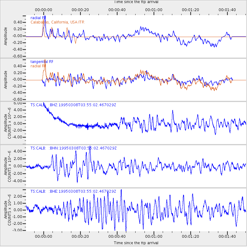
CALB Calabasas, California, USA - Earthquake Result Viewer
*The percent match for this event was below the threshold and hence no stack was calculated.
| Earthquake location: |
Leeward Islands |
| Earthquake latitude/longitude: |
16.6/-59.6 |
| Earthquake time(UTC): |
1995/03/08 (067) 03:45:59 GMT |
| Earthquake Depth: |
15 km |
| Earthquake Magnitude: |
6.3 MB, 6.2 MS, 6.4 UNKNOWN, 6.1 MD |
| Earthquake Catalog/Contributor: |
WHDF/NEIC |
|
| Network: |
TS TERRAscope (Southern California Seismic Network) |
| Station: |
CALB Calabasas, California, USA |
| Lat/Lon: |
34.14 N/118.63 W |
| Elevation: |
0.0 m |
|
| Distance: |
55.4 deg |
| Az: |
300.262 deg |
| Baz: |
92.831 deg |
| Ray Param: |
$rayparam |
*The percent match for this event was below the threshold and hence was not used in the summary stack. |
|
| Radial Match: |
44.52856 % |
| Radial Bump: |
400 |
| Transverse Match: |
60.84126 % |
| Transverse Bump: |
400 |
| SOD ConfigId: |
4480 |
| Insert Time: |
2010-02-26 14:03:35.334 +0000 |
| GWidth: |
2.5 |
| Max Bumps: |
400 |
| Tol: |
0.001 |
|
Signal To Noise
| Channel | StoN | STA | LTA |
| TS:CALB: :BHN:19950308T03:55:02.467029Z | 2.7489324 | 9.436996E-7 | 3.4329676E-7 |
| TS:CALB: :BHE:19950308T03:55:02.467029Z | 0.7643854 | 8.753596E-7 | 1.1451809E-6 |
| TS:CALB: :BHZ:19950308T03:55:02.467029Z | 0.96695584 | 1.7579612E-6 | 1.8180367E-6 |
| Arrivals |
| Ps | |
| PpPs | |
| PsPs/PpSs | |


