You are here: Home > Network List > TA - USArray Transportable Network (new EarthScope stations) Stations List
> Station M27A Reverse DX Ranch, Oshkosh, NE, USA > Earthquake Result Viewer
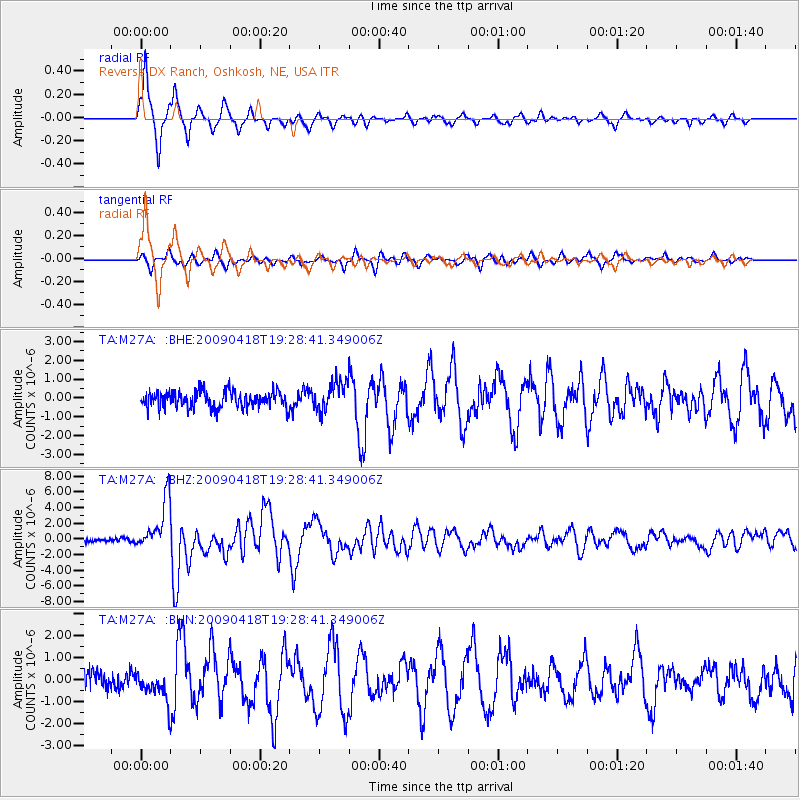
M27A Reverse DX Ranch, Oshkosh, NE, USA - Earthquake Result Viewer

| Earthquake location: |
Kuril Islands |
| Earthquake latitude/longitude: |
46.0/151.4 |
| Earthquake time(UTC): |
2009/04/18 (108) 19:17:58 GMT |
| Earthquake Depth: |
35 km |
| Earthquake Magnitude: |
6.3 MB, 6.3 MS, 6.6 MW, 6.4 MW |
| Earthquake Catalog/Contributor: |
WHDF/NEIC |
|
| Network: |
TA USArray Transportable Network (new EarthScope stations) |
| Station: |
M27A Reverse DX Ranch, Oshkosh, NE, USA |
| Lat/Lon: |
41.53 N/102.39 W |
| Elevation: |
1147 m |
|
| Distance: |
70.9 deg |
| Az: |
49.752 deg |
| Baz: |
314.894 deg |
| Ray Param: |
0.05464724 |
| Estimated Moho Depth: |
44.0 km |
| Estimated Crust Vp/Vs: |
1.82 |
| Assumed Crust Vp: |
6.483 km/s |
| Estimated Crust Vs: |
3.562 km/s |
| Estimated Crust Poisson's Ratio: |
0.28 |
|
| Radial Match: |
92.64764 % |
| Radial Bump: |
333 |
| Transverse Match: |
70.72933 % |
| Transverse Bump: |
400 |
| SOD ConfigId: |
2760 |
| Insert Time: |
2010-03-06 19:17:29.308 +0000 |
| GWidth: |
2.5 |
| Max Bumps: |
400 |
| Tol: |
0.001 |
|
Signal To Noise
| Channel | StoN | STA | LTA |
| TA:M27A: :BHZ:20090418T19:28:41.349006Z | 12.779943 | 3.2201813E-6 | 2.5197147E-7 |
| TA:M27A: :BHN:20090418T19:28:41.349006Z | 1.8030226 | 6.6405033E-7 | 3.682984E-7 |
| TA:M27A: :BHE:20090418T19:28:41.349006Z | 1.7833633 | 7.807519E-7 | 4.3779744E-7 |
| Arrivals |
| Ps | 5.8 SECOND |
| PpPs | 18 SECOND |
| PsPs/PpSs | 24 SECOND |


