You are here: Home > Network List > TA - USArray Transportable Network (new EarthScope stations) Stations List
> Station M27A Reverse DX Ranch, Oshkosh, NE, USA > Earthquake Result Viewer
M27A Reverse DX Ranch, Oshkosh, NE, USA - Earthquake Result Viewer

| Earthquake location: |
Off Coast Of Ecuador |
| Earthquake latitude/longitude: |
1.4/-85.2 |
| Earthquake time(UTC): |
2009/05/10 (130) 01:16:06 GMT |
| Earthquake Depth: |
6.0 km |
| Earthquake Magnitude: |
5.5 MB, 5.7 MS, 6.1 MW, 6.1 MW |
| Earthquake Catalog/Contributor: |
WHDF/NEIC |
|
| Network: |
TA USArray Transportable Network (new EarthScope stations) |
| Station: |
M27A Reverse DX Ranch, Oshkosh, NE, USA |
| Lat/Lon: |
41.53 N/102.39 W |
| Elevation: |
1147 m |
|
| Distance: |
42.9 deg |
| Az: |
340.931 deg |
| Baz: |
154.216 deg |
| Ray Param: |
0.07292589 |
| Estimated Moho Depth: |
51.75 km |
| Estimated Crust Vp/Vs: |
1.73 |
| Assumed Crust Vp: |
6.483 km/s |
| Estimated Crust Vs: |
3.753 km/s |
| Estimated Crust Poisson's Ratio: |
0.25 |
|
| Radial Match: |
83.39871 % |
| Radial Bump: |
400 |
| Transverse Match: |
63.504562 % |
| Transverse Bump: |
335 |
| SOD ConfigId: |
2760 |
| Insert Time: |
2010-03-06 19:17:31.436 +0000 |
| GWidth: |
2.5 |
| Max Bumps: |
400 |
| Tol: |
0.001 |
|
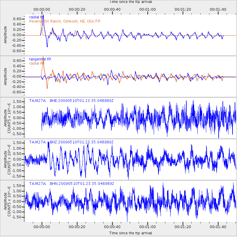
Signal To Noise
| Channel | StoN | STA | LTA |
| TA:M27A: :BHZ:20090510T01:23:35.048989Z | 2.638095 | 6.000155E-7 | 2.2744271E-7 |
| TA:M27A: :BHN:20090510T01:23:35.048989Z | 1.1214983 | 4.0289467E-7 | 3.5924677E-7 |
| TA:M27A: :BHE:20090510T01:23:35.048989Z | 1.0228306 | 4.2960014E-7 | 4.2001105E-7 |
| Arrivals |
| Ps | 6.2 SECOND |
| PpPs | 20 SECOND |
| PsPs/PpSs | 27 SECOND |


