You are here: Home > Network List > TA - USArray Transportable Network (new EarthScope stations) Stations List
> Station C17K DeLong Mountains, AK, USA > Earthquake Result Viewer
C17K DeLong Mountains, AK, USA - Earthquake Result Viewer
| Earthquake location: |
Northern Molucca Sea |
| Earthquake latitude/longitude: |
2.2/126.7 |
| Earthquake time(UTC): |
2019/01/06 (006) 17:27:20 GMT |
| Earthquake Depth: |
61 km |
| Earthquake Magnitude: |
6.6 mww |
| Earthquake Catalog/Contributor: |
NEIC PDE/us |
|
| Network: |
TA USArray Transportable Network (new EarthScope stations) |
| Station: |
C17K DeLong Mountains, AK, USA |
| Lat/Lon: |
68.48 N/163.18 W |
| Elevation: |
498 m |
|
| Distance: |
80.7 deg |
| Az: |
20.584 deg |
| Baz: |
252.17 deg |
| Ray Param: |
0.04798247 |
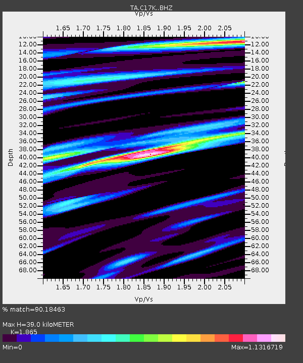
| Estimated Moho Depth: |
39.0 km |
| Estimated Crust Vp/Vs: |
1.87 |
| Assumed Crust Vp: |
5.906 km/s |
| Estimated Crust Vs: |
3.167 km/s |
| Estimated Crust Poisson's Ratio: |
0.30 |
|
| Radial Match: |
90.18463 % |
| Radial Bump: |
400 |
| Transverse Match: |
80.58946 % |
| Transverse Bump: |
400 |
| SOD ConfigId: |
13570011 |
| Insert Time: |
2019-05-02 06:44:31.420 +0000 |
| GWidth: |
2.5 |
| Max Bumps: |
400 |
| Tol: |
0.001 |
|

Signal To Noise
| Channel | StoN | STA | LTA |
| TA:C17K: :BHZ:20190106T17:38:56.224983Z | 8.35447 | 2.5861864E-6 | 3.095572E-7 |
| TA:C17K: :BHN:20190106T17:38:56.224983Z | 0.976938 | 3.5174108E-7 | 3.6004442E-7 |
| TA:C17K: :BHE:20190106T17:38:56.224983Z | 2.80551 | 6.982937E-7 | 2.4890082E-7 |
| Arrivals |
| Ps | 5.8 SECOND |
| PpPs | 19 SECOND |
| PsPs/PpSs | 24 SECOND |


