You are here: Home > Network List > TA - USArray Transportable Network (new EarthScope stations) Stations List
> Station D25K Kavik River, AK, USA > Earthquake Result Viewer
D25K Kavik River, AK, USA - Earthquake Result Viewer
| Earthquake location: |
Northern Molucca Sea |
| Earthquake latitude/longitude: |
2.2/126.7 |
| Earthquake time(UTC): |
2019/01/06 (006) 17:27:20 GMT |
| Earthquake Depth: |
61 km |
| Earthquake Magnitude: |
6.6 mww |
| Earthquake Catalog/Contributor: |
NEIC PDE/us |
|
| Network: |
TA USArray Transportable Network (new EarthScope stations) |
| Station: |
D25K Kavik River, AK, USA |
| Lat/Lon: |
69.32 N/146.38 W |
| Elevation: |
770 m |
|
| Distance: |
86.8 deg |
| Az: |
20.807 deg |
| Baz: |
267.871 deg |
| Ray Param: |
0.043659825 |
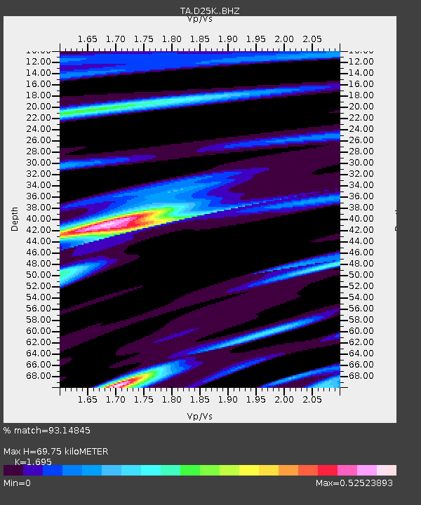
| Estimated Moho Depth: |
69.75 km |
| Estimated Crust Vp/Vs: |
1.70 |
| Assumed Crust Vp: |
6.378 km/s |
| Estimated Crust Vs: |
3.763 km/s |
| Estimated Crust Poisson's Ratio: |
0.23 |
|
| Radial Match: |
93.14845 % |
| Radial Bump: |
385 |
| Transverse Match: |
84.857 % |
| Transverse Bump: |
400 |
| SOD ConfigId: |
13570011 |
| Insert Time: |
2019-05-02 06:44:38.522 +0000 |
| GWidth: |
2.5 |
| Max Bumps: |
400 |
| Tol: |
0.001 |
|
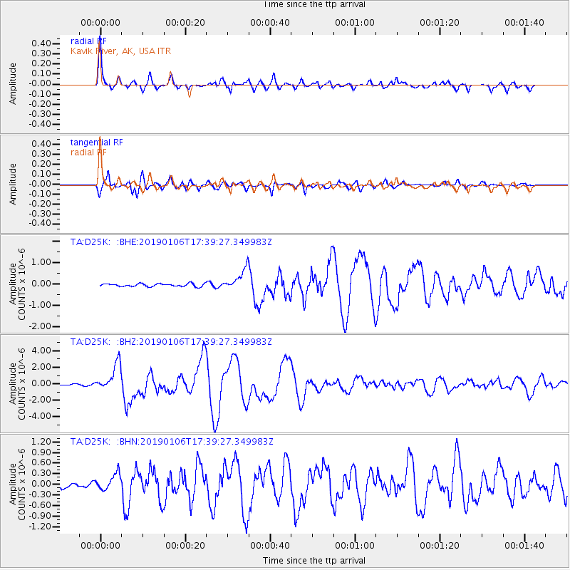
Signal To Noise
| Channel | StoN | STA | LTA |
| TA:D25K: :BHZ:20190106T17:39:27.349983Z | 15.208016 | 1.6985666E-6 | 1.116889E-7 |
| TA:D25K: :BHN:20190106T17:39:27.349983Z | 1.4626075 | 2.3669938E-7 | 1.6183384E-7 |
| TA:D25K: :BHE:20190106T17:39:27.349983Z | 7.9752426 | 5.4673023E-7 | 6.8553426E-8 |
| Arrivals |
| Ps | 7.8 SECOND |
| PpPs | 29 SECOND |
| PsPs/PpSs | 37 SECOND |


